

TITLE 4. CONSERVATION AND NATURAL RESOURCES
DEPARTMENT OF MINES, MINERALS AND ENERGY
Proposed Regulation
Title of Regulation: 4VAC25-150. Virginia Gas and Oil Regulation
(amending 4VAC25-150-10, 4VAC25-150-60, 4VAC25-150-80, 4VAC25-150-90,
4VAC25-150-100, 4VAC25-150-110, 4VAC25-150-120, 4VAC25-150-135, 4VAC25-150-140,
4VAC25-150-150, 4VAC25-150-160, 4VAC25-150-180, 4VAC25-150-190, 4VAC25-150-200,
4VAC25-150-210, 4VAC25-150-220, 4VAC25-150-230, 4VAC25-150-240, 4VAC25-150-250,
4VAC25-150-260, 4VAC25-150-280, 4VAC25-150-300, 4VAC25-150-310, 4VAC25-150-340,
4VAC25-150-360, 4VAC25-150-380, 4VAC25-150-390, 4VAC25-150-420, 4VAC25-150-460,
4VAC25-150-490, 4VAC25-150-500, 4VAC25-150-510, 4VAC25-150-520, 4VAC25-150-530,
4VAC25-150-550, 4VAC25-150-560, 4VAC25-150-590, 4VAC25-150-600, 4VAC25-150-610,
4VAC25-150-620, 4VAC25-150-630, 4VAC25-150-650, 4VAC25-150-660, 4VAC25-150-670,
4VAC25-150-680, 4VAC25-150-690, 4VAC25-150-700, 4VAC25-150-711, 4VAC25-150-720,
4VAC25-150-730, 4VAC25-150-740, 4VAC25-150-750).
Statutory Authority: §§ 45.1-161.3 and
45.1-361.27 of the Code of Virginia.
Public Hearing Information:
October 23, 2009 - 1 p.m. - Department of Mines, Minerals and Energy, 3405 Mountain Empire Road, Buchanan-Smith Building, Conference Room 219, Big Stone Gap, VA
Public Comments: Public comments may be
submitted until 5 p.m. on October 30, 2009.
Agency Contact: Tabitha Hibbitts Peace,
Policy Analyst, Department of Mines, Minerals and Energy, 3405 Mountain Empire
Road, P.O. Drawer 900, Big Stone Gap, VA 24219, telephone (276) 523-8212, FAX
(276) 523-8148, TTY (800) 828-1120, or email tabitha.peace@dmme.virginia.gov.
Basis: The Department of Mines, Minerals and Energy (DMME)
has authority to promulgate this regulation under the authority found in
§§ 45.1-161.3 and 45.1-361.27 of the Code of Virginia.
Section 45.1-161.3 of the Code of Virginia
empowers DMME, with the approval of the director, to promulgate regulations
necessary or incidental to the performance of duties or execution of powers
under Title 45.1 of the Code of Virginia.
Section 45.1-361.27 of the Code of Virginia
empowers the director to promulgate and enforce rules, regulations, and orders
necessary to ensure the safe and efficient development and production of gas
and oil resources located in the Commonwealth.
Purpose: The Department of Mines, Minerals and Energy
has determined the proposed regulatory amendments to various sections of
4VAC25-150 are necessary to protect the health, welfare, and safety of
citizens, reduce workload, and increase efficiency for permit applicants.
Technical corrections are necessary for accuracy and to provide clear language
consistent with state law. These amendments will aid the gas and oil industry
and the Virginia Gas and Oil Board in the approval and regulation of gas and
oil permits.
Substance: As a result of periodic review, the
Department of Mines, Minerals and Energy is amending 4VAC25-150, Virginia Gas
and Oil Regulation. Sections of 4VAC25-150 will be amended to correct technical
areas for accuracy, improve worker safety, and provide clarity. These
amendments will aid the gas and oil industry and the Gas and Oil Board in the
review and regulation of gas and oil permits.
Amending parts of 4VAC25-150-150 will reduce
workload and increase efficiency for applicants by providing flexibility and
economy to the permit process. 4VAC25-150-90 will be updated to include symbols
that are consistent with current industry usage and available CAD technology.
Amendments to 4VAC25-150-80, 4VAC25-150-260,
4VAC25-150-300, 4VAC25-150-380, and 4VAC25-150-630 will protect the safety and
health of oil and gas industry employees.
An amendment to 4VAC25-150-90 is being made
to bring consistency to data submission requirements for the Division of Gas
and Oil. The use of latitude and longitude and the Virginia Coordinate System
of 1927 have been replaced by the Virginia Coordinate System of 1983 in other
Division of Gas and Oil regulations. Current industry practice to use the more
modern 1983 coordinate system for describing the locations of wells and core
holes. Applicants for permits under this chapter must currently convert their
coordinates back to the 1927 system, as required by the regulation, in order to
submit them to the Department of Mines, Minerals and Energy’s Division of Gas
and Oil. The amendment will allow applicants to use the updated 1983 coordinate
system.
Issues: These regulatory actions are expected to
provide technical corrections, improve clarity, increase efficiency, and to
restore consistency with other chapters of regulation. These amendments
regarding process will aid the gas and oil industry, as well as the Gas and Oil
Board in the review and regulation of gas and oil permits. Reduced workload and
increased efficiency for applicants will occur by providing flexibility and
economy in the permit process.
The Department of Planning and Budget's
Economic Impact Analysis:
Summary of the Proposed Amendments to
Regulation. As a result of periodic review, the Department of Mines, Minerals
and Energy (DMME) proposes numerous amendments to the Virginia Gas & Oil
Regulations, including: 1) adding a definition for "red zone," 2)
updating required symbols to the current industry standard CAD template, 3)
adding a requirement that operations plan specify "red zone" areas, 4)
increasing the application fee for transfer of permit rights from $65 to $75,
5) eliminating the requirement to mail pemit approvals to all persons given
notice of the hearing, but maintaining the requirement to mail pemit denials to
all persons given notice of the hearing, 6) extending reporting deadlines from
30 or 45 days to 90 days, 7) changing required notification of
ground-disturbing activity from at least two working days prior to commencing
ground-disturbing activity to at least 48 hours prior, 8) adding requirement
for posting red zone signs, 9) reduce specificity of topsoil requirement so
that any soil suitable for stabilizing the site with vegetation can be used,
10) allowing any form of variance request, 11) changing the specific
circumstances under which an inclination survey must be performed, 12) adding a
requirement that all pits be reclaimed within 90 days unless a variance is
granted by the field inspector, and 13) adding a new section defining the
length of time wells can remain shut in without a requirement for plugging.
Result of Analysis. The benefits exceed the
costs for one or more proposed changes. There is insufficient data to
accurately compare the magnitude of the benefits versus the costs for other
changes.
Estimated Economic Impact. DMME proposes
several amendments to these regulations merely reflect modern usage such as
GPS, electronic communication, and the use of the current industry standard CAD
template. Virginia’s gas and oil industry through the representation of the Virginia
Gas and Oil Association (VGOA) has expressed approval of these changes and
generally agrees that these types of changes are beneficial.
The proposed regulations define "red
zone" as a zone in or contiguous to a permitted area that could have
potential hazards to workers or to the public. Further, the proposed
regulations require that operation plans identify red zone areas and that red
zone signs be posted to alert the public and workers of the hazards in the
area. VGOA estimates that this proposed requirement will add $1,000 to $2,000
of cost per plan and approximately $100 per sign, but agrees that it will
potentially significantly reduce safety risks. Thus, these proposed changes
likely produce a net benefit.
DMME proposes to increase the application fee
for transfer of permit rights from $65 to $75. According to the agency even the
proposed higher fee falls far short of covering their regulating expenses. VGOA
does not oppose the fee increase.
Under the current regulations, in hearings on
objections to permit applications the DMME director must mail his decision to
all parties given notice of the hearing. DMME proposes to eliminate the
requirement to mail pemit approvals to all persons given notice of the hearing,
but to continue to require that pemit denials be sent to all persons given
notice of the hearing. Parties directly involved would still be notified of
permit approvals of course. The proposed change would reduce some small costs
in time for DMME staff, but it is unclear whether the small reduction in time
cost exceeds the reduced benefit in informing interested members of the public.
The current regulations include various
reporting deadlines of either 30 days or 45 days which DMME proposes to extend
to 90 days. The extra time will be beneficial for firms and DMME states that
the extra time for reporting is unlikely to significantly affect health and
safety. Thus, these proposed longer deadlines will likely produce a net
benefit.
The agency proposes to change the required
notification of ground-disturbing activity from at least two working days prior
to commencing ground-disturbing activity to at least 48 hours prior. According
to DMME, staff is available to receive notification on the weekends and 48
hours notice is sufficient to ensure safety. This proposed change allows firms
to not have to proceed with work one or two days sooner at times without
negatively affected safety. Consequently, this proposed change produces a net
benefit for the Commonwealth.
DMME also proposes some additional options
for satisfying requirements that will reduce costs for firms without
compromising safety or the environment. Under the current regulations during
construction topsoil sufficient to provide a suitable growth medium for
permanent stabilization with vegetation must be used to stabilize the site. The
agency proposes to permit the use of soil that is not necessarily topsoil, but
which still can provide a suitable growth medium for permanent stabilization
with vegetation. Also the timing for acceptance of variances is less
restrictive under the proposed regulations.
The current regulations require that an
inclination survey be performed prior to drilling into a coal seam where active
mining is being conducted. DMME proposes to instead require that an inclination
survey be performed prior to drilling within 500 feet of a coal seam where
workers are assigned travel, etc. According to DMME their definition of active
mining includes where coal workers are not currently working; and thus under
the proposed language there will be fewer instances where inclination surveys
are required. VGOA estimates that inclination surveys cost $2,000 to $3,000 per
well. Since only instances where coal workers are not present will be
eliminated from when an inclination survey is required, the proposed change
should not negatively affect safety while saving $2,000 to $3,000 per instance
where the inclination survey is no longer required.
The regulations state that "Pits are to
be temporary in nature and are to be reclaimed when the operations using the
pit are complete. DMME proposes to add that "All pits shall be reclaimed
within 90 days unless a variance is granted by the field inspector."
Reclamation concerns meeting water quality standards. According to VGOA,
mandatory reclamation within 90 days can significantly add to costs. VGOA
states that drought conditions can cause pits to not meet water quality
standards that would meet the standards under non-drought conditions, causing
firms to spend thousands of dollars which they could have avoided if they were
not required to act within 90 days. The counter argument would be that there
are environmental costs to the pits not meeting water quality standards and
perhaps the benefits of improved environment are worth those costs.
Abandoned wells are required to be plugged to
prevent environmental damage and safety risks from leaks. DMME proposes to
require that permittees submit either a well plugging plan or a future well
production plan for wells that have been in non-producing status for two years.
Further, the agency proposes that "In no circumstance shall a
non-producing well remain un-plugged for more than a three year period unless
approved by the director (of DMME)." The intent of this proposal is to
limit the existence of non-producing wells that may be producing environmental
damage through leaks.
The proposed plugging requirement may produce
large costs and could discourage natural gas production. According to VGOA it
costs approximately $20,000 to plug a well, and from $350,000 to $500,000 to
drill a new well. VGOA states that it is essentially not feasible to unplug a
plugged well, and thus would cost another $350,000 to $500,000 to re-drill a
well at the site of a plugged well. The proposed plugging requirement would
discourage some natural gas production (according to VGOA) in that the time
frame that a well could be used would be reduced and thus the potential
benefits of drilling in new locations would be reduced. Thus it is not clear
that the potential environmental benefits of requiring plugging within three
years would exceed the costs.
Businesses and Entities Affected. According
to the Department of Mines, Minerals and Energy, four companies drill most oil
and gas wells in Virginia and an unknown number of other companies may also
undertake such activities from time to time. None of these would be defined as
small businesses.
Localities Particularly Affected. The
proposed regulations particularly affect the City of Norton and the following
counties: Buchanan, Dickenson, Lee, Russell, Scott, Tazewell, Washington and
Wise.
Projected Impact on Employment. Most of the
proposed amendments would not significantly affect employment. The proposal to
require plugging for wells not used for three years might discourage some
natural gas drilling and might have some negative impact on employment.
Effects on the Use and Value of Private
Property. Several of the proposed amendments add moderate costs for oil and gas
firms in order to improve public safety and the environment. These changes may have
some moderate positive affect on the value of neighboring properties. Some of
the proposed amendments reduce costs foe firms without compromising safety or
the environment. These changes will provide some counterbalance to the
aforementioned increased costs. The proposal to requiring plugging for wells
not in use for three years may produce larger costs for private firms.
Small Businesses: Costs and Other Effects.
According to DMME, none of the firms directly affected by the proposed
regulations are small businesses. Small businesses that serve the large firms
may be indirectly affected.
Small Businesses: Alternative Method that
Minimizes Adverse Impact. According to DMME, none of the firms directly
affected by the proposed regulations are small businesses.
Real Estate Development Costs. This
regulation concerns the use of land for gas and oil acquisition. Several
proposed changes that increase public safety or reduce environmental risk, such
as requiring red zone signs, add moderate costs. Some proposed changes, such as
permitting the use of soil that is not necessarily topsoil, but which still can
provide a suitable growth medium for permanent stabilization with vegetation,
moderately reduce land use costs.
Legal Mandate. The Department of Planning and
Budget (DPB) has analyzed the economic impact of this proposed regulation in
accordance with § 2.2-4007.04 of the Administrative Process Act and
Executive Order Number 36 (06). Section 2.2-4007.04 requires that such economic
impact analyses include, but need not be limited to, the projected number of
businesses or other entities to whom the regulation would apply, the identity
of any localities and types of businesses or other entities particularly
affected, the projected number of persons and employment positions to be
affected, the projected costs to affected businesses or entities to implement
or comply with the regulation, and the impact on the use and value of private
property. Further, if the proposed regulation has adverse effect on small
businesses, § 2.2-4007.04 requires that such economic impact analyses
include (i) an identification and estimate of the number of small businesses
subject to the regulation; (ii) the projected reporting, recordkeeping, and
other administrative costs required for small businesses to comply with the
regulation, including the type of professional skills necessary for preparing
required reports and other documents; (iii) a statement of the probable effect
of the regulation on affected small businesses; and (iv) a description of any
less intrusive or less costly alternative methods of achieving the purpose of
the regulation. The analysis presented above represents DPB’s best estimate of
these economic impacts.
Agency's Response to the Department of
Planning and Budget's Economic Impact Analysis: The agency concurs with
Department of Planning and Budget's economic impact analysis.
Summary:
As a result of periodic
review, the Department of Mines, Minerals and Energy is amending 4VAC25-150,
Virginia Gas and Oil Regulation. Sections within 4VAC25-150 will be amended to
correct technical areas for accuracy, improve worker safety, and provide
clarity. These amendments will aid the gas and oil industry and the Gas and Oil
Board in the review and regulation of gas and oil permits. Amending
4VAC25-150-150 will reduce workload and increase efficiency for applicants by
providing flexibility and economy to the permit process. 4VAC25-150-90 will be
updated to include symbols that are consistent with current industry usage and
available CAD technology. Amendments to 4VAC25-150-80, 4VAC25-150-260,
4VAC25-150-300, 4VAC25-150-380, and 4VAC25-150-630 will protect the safety and
health of oil and gas industry employees. An amendment to 4VAC25-150-90 is
being made to bring consistency to data submission requirements for the
Division of Gas and Oil.
Part I
Standards of General Applicability
Article 1
General Information
4VAC25-150-10. Definitions.
The following words and
terms, when used in this chapter, shall have the following
meaning unless the context clearly indicates otherwise:
"Act" means the
Virginia Gas and Oil Act of 1990, Chapter 22.1 (§ 45.1-361.1 et seq.) of Title
45.1 of the Code of Virginia.
"Adequate channel"
means a watercourse that will convey the designated frequency storm event
without overtopping its banks or causing erosive damage to the bed, banks and
overbank sections.
"Applicant" means
any person or business who files an application with the Division of Gas and
Oil.
"Approved" means
accepted as suitable for its intended purpose when included in a permit issued
by the director or determined to be suitable in writing by the director.
"Berm" means a
ridge of soil or other material constructed along an active earthen fill to
divert runoff away from the unprotected slope of the fill to a stabilized
outlet or sediment trapping facility.
"Board" means the
Virginia Gas and Oil Board.
"Bridge plug"
means an obstruction intentionally placed in a well at a specified depth.
"Cased completion"
means a technique used to make a well capable of production in which production
casing is set through the productive zones.
"Cased/open hole
completion" means a technique used to make a well capable of production in
which at least one zone is completed through casing and at least one zone is completed
open hole.
"Casing" means all
pipe set in wells except conductor pipe and tubing.
"Causeway" means a
temporary structural span constructed across a flowing watercourse or wetland
to allow construction traffic to access the area without causing erosion
damage.
"Cement" means
hydraulic cement properly mixed with water.
"Channel" means a
natural stream or man-made waterway.
"Chief" means the
Chief of the Division of Mines of the Department of Mines, Minerals and Energy.
"Coal-protection
string" means a casing designed to protect a coal seam by excluding all
fluids, oil, gas or gas pressure from the seam, except such as may be found in
the coal seam itself.
"Cofferdam" means
a temporary structure in a river, lake or other waterway for keeping the water
from an enclosed area that has been pumped dry so that bridge foundations,
pipelines, etc., may be constructed.
"Completion" means
the process which results in a well being capable of producing gas or oil.
"Conductor pipe"
means the short, large diameter string used primarily to control caving and
washing out of unconsolidated surface formations.
"Corehole" means
any shaft or hole sunk, drilled, bored or dug, that breaks or
disturbs the surface of the earth as part of a geophysical operation solely
for the purpose of obtaining rock samples or other information to be used in
the exploration for coal, gas, or oil. The term shall not
include a borehole used solely for the placement of an explosive charge or
other energy source for generating seismic waves.
"Days" means
calendar days.
"Denuded area"
means land that has been cleared of vegetative cover.
"Department" means
the Department of Mines, Minerals and Energy.
"Detention basin"
means a stormwater management facility which temporarily impounds and
discharges runoff through an outlet to a downstream channel. Infiltration is
negligible when compared to the outlet structure discharge rates. The facility
is normally dry during periods of no rainfall.
"Dike" means an
earthen embankment constructed to confine or control fluids.
"Directional
survey" means a well survey that measures the degree of deviation of a
hole, or distance from the vertical and the direction of deviation from
true vertical, and the distance and direction of points in the hole from
vertical.
"Director" means
the Director of the Department of Mines, Minerals and Energy or his authorized
agent.
"Diversion" means
a channel constructed for the purpose of intercepting surface runoff.
"Diverter" or
"diverter system" means an assembly of valves and piping attached to
a gas or oil well's casing for controlling flow and pressure from a well.
"Division" means
the Division of Gas and Oil of the Department of Mines, Minerals and Energy.
"Erosion and sediment
control plan" means a document containing a description of materials and
methods to be used for the conservation of soil and the protection of water
resources in or on a unit or group of units of land. It may include appropriate
maps, an appropriate soil and water plan inventory and management information
with needed interpretations, and a record of decisions contributing to
conservation treatment. The plan shall contain a record of all major
conservation decisions to ensure that the entire unit or units of land will be
so treated to achieve the conservation objectives.
"Expanding cement"
means any cement approved by the director which expands during the hardening
process, including but not limited to regular oil field cements with the proper
additives.
"Form prescribed by the
director" means a form issued by the division, or an equivalent facsimile,
for use in meeting the requirements of the Act or this chapter.
"Firewall" means
an earthen dike or fire resistant structure built around a tank or tank battery
to contain the oil in the event a tank ruptures or catches fire.
"Flume" means a
constructed device lined with erosion-resistant materials intended to convey
water on steep grades.
"Flyrock" means
any material propelled by a blast that would be actually or potentially
hazardous to persons or property.
"Gas well" means
any well which produces or appears capable of producing a ratio of 6,000 cubic
feet (6 Mcf) of gas or more to each barrel of oil, on the basis of a gas-oil
ratio test.
"Gob well" means a
coalbed methane gas well which is capable of producing coalbed methane gas from
the de-stressed zone associated with any full-seam extraction of coal that
extends above and below the mined-out coal seam.
"Groundwater"
means all water under the ground, wholly or partially within or bordering the
Commonwealth or within its jurisdiction, which has the potential for being used
for domestic, industrial, commercial or agricultural use or otherwise affects
the public welfare.
"Highway" means
any public street, public alley, or public road.
"Inclination
survey" means a well or corehole survey, using the surface location of
the well or corehole as the apex, to determine the deviation of the well or
corehole from the true vertical beneath the apex on the same horizontal
subsurface plane survey taken inside a wellbore that measures the degree
of deviation of the point of the survey from true vertical.
"Inhabited
building" means a building, regularly occupied in whole or in part by
human beings, including, but not limited to, a private residence, church,
school, store, public building or other structure where people are accustomed
to assemble except for a building being used on a temporary basis, on a
permitted site, for gas, oil, or geophysical operations.
"Intermediate
string" means a string of casing that prevents caving, shuts off connate
water in strata below the water-protection string, and protects strata from
exposure to lower zone pressures.
"Live watercourse"
means a definite channel with bed and banks within which water flows continuously.
"Mcf" means, when
used with reference to natural gas, 1,000 cubic feet of gas at a pressure base
of 14.73 pounds per square inch gauge and a temperature base of 60°F.
"Mud" means any
mixture of water and clay or other material as the term is commonly used in the
industry a mixture of materials that creates a weighted fluid to be
circulated down hole during drilling operations for the purpose of lubricating
and cooling the bit, removing cuttings, and controlling formation pressures and
fluid.
"Natural channel"
or "natural stream" means nontidal waterways that are part of the
natural topography. They usually maintain a continuous or seasonal flow during
the year, and are characterized as being irregular in cross section with a
meandering course.
"Nonerodible"
means a material such as riprap, concrete or plastic that will not experience
surface wear due to natural forces.
"Oil well" means
any well which produces or appears capable of producing a ratio of less than
6,000 cubic feet (6 Mcf) of gas to each barrel of oil, on the basis of a
gas-oil ratio test.
"Open hole
completion" means a technique used to make a well capable of production in
which no production casing is set through the productive zones.
"Person" means any
individual, corporation, partnership, association, company, business, trust,
joint venture or other legal entity.
"Petitioner" means
any person or business who files a petition, appeal, or other request for
action with the Division of Gas and Oil or the Virginia Gas and Oil Board.
"Plug" means the stopping
sealing of, or a device or material used for the stopping sealing
of, the flow of water, a gas or oil wellbore or casing to
prevent the migration of water, gas, or oil from one stratum to another.
"Pre-development"
means the land use and site conditions that exist at the time that the
operations plan is submitted to the division.
"Produced waters"
means water or fluids produced from a gas well, oil well, coalbed methane gas
well or gob well as a byproduct of producing gas, oil or coalbed methane gas.
"Producer" means a
permittee operating a well in Virginia that is producing or is capable of
producing gas or oil.
"Production
string" means a string of casing or tubing through which the well is
completed and may be produced and controlled.
"Red shales" means
the undifferentiated shaley portion of the bluestone Bluestone
formation normally found above the Pride Shale Member of the formation, and
extending upward to the base of the Pennsylvanian strata, which red shales are
predominantly red and green in color but may occasionally be gray, grayish
green and grayish red.
"Red zone" is a
zone in or contiguous to a permitted area that could have potential hazards to
workers or to the public.
"Retention basin"
means a stormwater management facility which, similar to a detention basin,
temporarily impounds runoff and discharges its outflow through an outlet to a
downstream channel. A retention basin is a permanent impoundment.
"Sediment basin"
means a depression formed from the construction of a barrier or dam built to
retain sediment and debris.
"Sheet flow," also
called overland flow, means shallow, unconcentrated and irregular flow down a
slope. The length of strip for sheet flow usually does not exceed 200 feet
under natural conditions.
"Slope drain"
means tubing or conduit made of nonerosive material extending from the top to
the bottom of a cut or fill slope.
"Special
diligence" means the activity and skill exercised by a good businessman
businessperson in his a particular specialty, which must
be commensurate with the duty to be performed and the individual circumstances
of the case; not merely the diligence of an ordinary person or nonspecialist.
"Stabilized" means
able to withstand normal exposure to air and water flows without incurring
erosion damage.
"Stemming" means
the inert material placed in a borehole after an explosive charge for the
purpose of confining the explosion gases in the borehole or the inert material
used to separate the explosive charges (decks) in decked holes.
"Storm sewer
inlet" means any structure through which stormwater is introduced into an
underground conveyance system.
"Stormwater management
facility" means a device that controls stormwater runoff and changes the
characteristics of that runoff, including but not limited to, the quantity,
quality, the period of release or the velocity of flow.
"String of pipe"
or "string" means the total footage of pipe of uniform size set in a
well. The term embraces conductor pipe, casing and tubing. When the casing
consists of segments of different size, each segment constitutes a separate
string. A string may serve more than one purpose.
"Sulfide stress
cracking" means embrittlement of the steel grain structure to reduce
ductility and cause extreme brittleness or cracking by hydrogen sulfide.
"Surface mine"
means an area containing an open pit excavation, surface operations incident to
an underground mine, or associated activities adjacent to the excavation or
surface operations, from which coal or other minerals are produced for sale,
exchange, or commercial use; and includes all buildings and equipment above the
surface of the ground used in connection with such mining.
"Target formation"
means the geologic gas or oil formation identified by the well operator in his
application for a gas, oil or geophysical drilling permit.
"Temporary stream
crossing" means a temporary span installed across a flowing watercourse
for use by construction traffic. Structures may include bridges, round pipes or
pipe arches constructed on or through nonerodible material.
"Ten-year storm"
means a storm that is capable of producing rainfall expected to be equaled or
exceeded on the average of once in 10 years. It may also be expressed as an
exceedance probability with a 10% chance of being equaled or exceeded in any
given year.
"Tubing" means the
small diameter string set after the well has been drilled from the surface to
the total depth and through which the gas or oil or other substance is produced
or injected.
"Two-year storm"
means a storm that is capable of producing rainfall expected to be equaled or
exceeded on the average of once in two years. It may also be expressed as an
exceedance probability with a 50% chance of being equaled or exceeded in any
given year.
"Vertical ventilation
hole" means any hole drilled from the surface to the coal seam used only
for the safety purpose of removing gas from the underlying coal seam and the
adjacent strata, thus, removing the gas that would normally be in the mine
ventilation system.
"Water bar" means
a small obstruction constructed across the surface of a road, pipeline
right-of-way, or other area of ground disturbance in order to interrupt and
divert the flow of water down the on a grade of the road
and divert the water to provide for sediment control for the purpose of
controlling erosion and sediment migration.
"Water-protection
string" means a string of casing designed to protect groundwater-bearing
strata.
4VAC25-150-60. Due dates for
reports and decisions.
A. Where the last day fixed
for (i) submitting a request for a hearing, holding a hearing or
issuing a decision in an enforcement action under Article 3 (4VAC25-150-170 et
seq.) of this part, (ii) submitting a monthly or annual report under Article 4
(4VAC25-150-210 et seq.) of this part, (iii) submitting a report of
commencement of activity under 4VAC25-150-230, (iv) submitting a drilling
report, a completion report or other report under 4VAC25-150-360, or (v)
submitting a plugging affidavit under 4VAC25-150-460 or any required
report falls on a Saturday, Sunday, or any day on which the Division of Gas
and Oil office is closed as authorized by the Code of Virginia or the Governor,
the required action may be done on the next day that the office is open.
B. All submittals to or notifications
of the Division of Gas and Oil identified in subsection A of this section shall
be made to the division office no later than 5 p.m. on the day required by the
Act or by this chapter.
Article 2
Permitting
4VAC25-150-80. Application
for a permit.
A. Applicability.
1. Persons required in § 45.1-361.29 of the
Code of Virginia to obtain a permit or permit modification shall apply to the
division on the forms prescribed by the director. All lands on which gas, oil
or geophysical operations are to be conducted shall be included in a permit
application.
2. In addition to specific requirements for
variances in other sections of this chapter, any applicant for a variance
shall, in writing, document the need for the variance and describe the
alternate measures or practices to be used.
B. The application for a
permit shall, as applicable, be accompanied by the fee in accordance with §
45.1-361.29 of the Code of Virginia, the bond in accordance with § 45.1-361.31
of the Code of Virginia, and the fee for the Orphaned Well Fund in accordance
with § 45.1-361.40 of the Code of Virginia.
C. Each application for a
permit shall include information on all activities, including those involving
associated facilities, to be conducted on the permitted site. This shall
include the following:
1. The name and address of:
a. The gas, oil or geophysical applicant;
b. The agent required to be designated under
§ 45.1-361.37 of the Code of Virginia; and
c. Each person whom the applicant must notify
under § 45.1-361.30 of the Code of Virginia;
2. The certifications required in §
45.1-361.29 E of the Code of Virginia;
3. The proof of notice to affected parties
required in § 45.1-361.29 E of the Code of Virginia, which shall be:
a. A copy of a signed receipt or electronic
return receipt of delivery of notice by certified mail;
b. A copy of a signed receipt acknowledging
delivery of notice by hand; or
c. If all copies of receipt of delivery of
notice by certified mail have not been signed and returned within 15 days of mailing,
a copy of the mailing log or other proof of the date the notice was sent by
certified mail, return receipt requested;
4. If the application is for
a permit modification, proof of notice to affected parties, as specified in
subdivision C 3 of this section;
4. 5. Identification
of the type of well or other gas, oil or geophysical operation being proposed;
5. 6. The plat in
accordance with 4VAC25-150-90;
6. 7. The operations
plan in accordance with 4VAC25-150-100;
7. 8. The information
required for operations involving hydrogen sulfide in accordance with
4VAC25-150-350;
8. 9. The location
where the Spill Prevention Control and Countermeasure (SPCC) plan is available,
if one is required;
9. 10. The Department
of Mines, Minerals and Energy, Division of Mined Land Reclamation's permit
number for any area included in a Division of Mined Land Reclamation permit on
which a proposed gas, oil or geophysical operation is to be located;
10. 11. For an
application for a conventional well, the information required in
4VAC25-150-500;
11. 12. For an
application for a coalbed methane gas well, the information required in
4VAC25-150-560;
12. 13. For an
application for a geophysical operation, the information required in
4VAC25-150-670; and
13. 14. For an application
for a permit to drill for gas or oil in Tidewater Virginia, the environmental
impact assessment meeting the requirements of § 62.1-195.1 B of the Code of
Virginia.
D. After July 1, 2009, all
permit applications and plats submitted to the division shall be in electronic
form or a format prescribed by the director.
4VAC25-150-90. Plats.
A. When filing an
application for a permit for a well or corehole, the applicant also shall file
an accurate plat certified by a licensed professional engineer or licensed land
surveyor on a scale, to be stated thereon, of 1 inch equals 400 feet (1:4800).
The scope of the plat shall be large enough to show the board approved unit
and all areas within the greater of 750 feet or one half of the distance
specified in § 45.1-361.17 of the Code of Virginia from the proposed well or
corehole, or within a unit established by the board for the subject well.
The plat shall be submitted on a form prescribed by the director.
B. The known courses and
distances of all property lines and lines connecting the permanent points,
landmarks or corners within the scope of the plat shall be shown thereon. All
lines actually surveyed shall be shown as solid lines. Lines taken from deed or
chain of title descriptions only shall be shown by broken lines. All
property lines shown on a plat shall agree with surveys, deed descriptions, or
acreages used in county records for tax assessment purposes.
C. A north and south line
shall be given and shown on the plat, and point to the top of the plat.
D. Wells or coreholes shall
be located on the plat as follows:
1. The proposed or actual surface elevation
of the subject well or corehole shall be shown on the plat, within an accuracy
of one vertical foot. The surface elevation shall be tied to either a government
benchmark or other point of proven elevation by differential or aerial survey,
or by trigonometric leveling, or by Global Positioning System (GPS)
survey. The location of the government benchmark or the point of proven
elevation and the method used to determine the surface elevation of the subject
well or corehole shall be noted and described on the plat.
2. The proposed or actual horizontal location
of the subject well or corehole determined by survey shall be shown on the
plat. The proposed or actual well or corehole location shall be shown in
accordance with the Virginia Coordinate System of 1983, as defined in Chapter
17 (§ 55-287 et seq.) of Title 55 of the Code of Virginia, also known as the
State Plane Coordinate System.
3. The courses and distances of the well or
corehole location from two permanent points or landmarks on the tract shall be
shown; such landmarks shall be set stones, iron pipes, T-rails or other
manufactured monuments, including mine coordinate monuments, and operating or
abandoned wells which are platted to the accuracy standards of this section and
on file with the division. If temporary points are to be used to locate the
actual well or corehole location as provided for in 4VAC25-150-290, the courses
and distances of the well or corehole location from the two temporary points
shall be shown.
4. Any other well, permitted or drilled,
within the distance specified in § 45.1-361.17 of the Code of Virginia or the
distance to the nearest well completed in the same pool, whichever is less, or
within the boundaries of a drilling unit established by the board around the
subject well shall be shown on the plat or located by notation. The type of
each well shall be designated by the following symbols as described in the
Federal Geographic Data Committee (FGDC) Digital Cartographic Standard for
Geologic Map Symbolization:
Symbols for additional
features as required in 4VAC25-150-510, 4VAC25-150-590, and 4VAC25-150-680
should be taken from the FDGC standard where applicable.
E. Plats shall also contain:
1. For a conventional gas and oil or
injection well, the information required in 4VAC25-150-510;
2. For a coalbed methane gas well, the
information required in 4VAC25-150-590; or
3. For a corehole, the information required
in 4VAC25-150-680.
F. Any subsequent application
for a new permit or permit modification shall include an accurate copy of the
well plat, updated as necessary to reflect any changes on the site, newly
discovered data or additional data required since the last plat was submitted.
Any revised plat shall be certified as required in subsection A of this
section.
4VAC25-150-100. Operations
plans.
A. Each application for a
permit or permit modification shall include an operations plan, in a format
approved by or on a form prescribed by the director. The operations plan and
accompanying maps or drawings shall become part of the terms and conditions of
any permit which is issued.
B. The applicant shall
indicate how risks to the public safety or to the site and adjacent lands are
to be managed, consistent with the requirements of § 45.1-361.27 B of the Code
of Virginia, and shall provide a short narrative, if pertinent. The
operations plan shall identify "red zone" areas.
4VAC25-150-110. Permit
supplements and permit modifications.
A. Permit supplements.
1. Standard permit supplements. A permittee
shall be allowed to submit a permit supplement when work being performed either:
a. Does not change the disturbance area as
described in the original permit; or and
b. Involves activities previously permitted.
The permittee shall submit written
documentation of the changes made to the permitted area within seven working
no later than 30 days after completing the change. All other changes to
the permit shall require a permit modification in accordance with § 45.1-361.29
of the Code of Virginia.
2. Emergency permit supplements. If a change
must be implemented immediately for an area off the disturbance area as
described in the original permit, or for an activity not previously permitted
due to actual or threatened imminent danger to the public safety or to the
environment, the permittee shall:
a. Take immediate action to minimize the
danger to the public or to the environment;
b. Orally notify Notify the
director as soon as possible of actions taken to minimize the danger and, if
the director determines an emergency still exists and grants oral approval,
commence additional changes if necessary; and
c. Submit a written supplement to the
permit within seven working days of notifying the director with a written
description of the emergency and action taken. The supplement shall
contain a description of the activity which was changed, a description of the
new activity, and any amended data, maps, plats, or other information required
by the director. An incident report may also be required as provided for
in 4VAC25-150-380.
Any changes to the permit
are to be temporary and restricted to those that are absolutely necessary to
minimize danger. Any permanent changes to the permit shall require a permit
modification as provided for in subsection B of this section.
B. Permit modifications.
1. Applicability. All changes to the permit
which do not fit the description contained in subsection A of this section
shall require a permit modification in accordance with § 45.1-361.29 of the
Code of Virginia.
2. Notice and fees. Notice of a permit
modification shall be given in accordance with § 45.1-361.30 of the Code of
Virginia. The application for a permit modification shall be accompanied, as
applicable, by the fee in accordance with § 45.1-361.29 of the Code of Virginia
and the bond in accordance with § 45.1-361.31 of the Code of Virginia.
3. Waiver of right to object. Upon receipt of
notice, any person may, on a form approved by the director, waive the time
requirements and their right to object to a proposed permit modification. The
department shall be entitled to rely upon the waiver to approve the permit
modification.
4. Permit modification. The permittee shall
submit a written application for a permit modification on a form prescribed by
the director. The permittee may not undertake the proposed work until the
permit modification has been issued. The As appropriate, the
application shall include, but not be limited to:
a. The name and address of:
(1) The permittee; and
(2) Each person whom the applicant must
notify under § 45.1-361.30 of the Code of Virginia;
b. The certifications required in §
45.1-361.29 E of the Code of Virginia;
c. The proof of notice required in §
45.1-361.29 E of the Code of Virginia, as provided for in 4VAC25-150-80 C 3;
d. Identification of the type of work for
which a permit modification is requested;
e. The plat in accordance with 4VAC25-150-90;
f. All data, maps, plats and plans in
accordance with 4VAC25-150-100 necessary to describe the activity proposed to
be undertaken;
g. When the permit modification includes
abandoning a gas or oil well as a water well, a description of the plugging to
be completed up to the water-bearing formation and a copy of the permit issued
for the water well by the Virginia Department of Health;
h. The information required for operations
involving hydrogen sulfide in accordance with 4VAC25-150-350 if applicable to
the proposed operations;
i. The location where the Spill Prevention
Control and Countermeasure (SPCC) plan is available, if one has been developed
for the site of the proposed operations;
j. The Department of Mines, Minerals and
Energy, Division of Mined Land Reclamation's permit number for any area
included in a Division of Mined Land Reclamation permit; and
k. The information, as appropriate, required
in 4VAC25-150-500, 4VAC25-150-560, or 4VAC25-150-670, or
4VAC25-150-720.
4VAC25-150-120. Transfer of
permit rights.
A. Applicability.
1. No transfer of rights granted by a permit
shall be made without prior approval from the director.
2. Any approval granted by the director of a
transfer of permit rights shall be conditioned upon the proposed new operator
complying with all requirements of the Act, this chapter and the permit.
B. Application. Any person requesting
a transfer of rights granted by a permit shall submit a written application on
a form prescribed by the director. The application shall be accompanied by a
fee of $65 $75 and bond, in the name of the person requesting the
transfer, in accordance with § 45.1-361.31 of the Code of Virginia. The
application shall contain, but is not limited to:
1. The name and address of the current
permittee, the current permit number and the name of the current operation;
2. The name and address of the proposed new
operator and the proposed new operations name;
3. Documentation of approval of the transfer
by the current permittee;
4. If the permit was issued on or before
September 25, 1991, an updated operations plan, in accordance with
4VAC25-150-100, showing how all permitted activities to be conducted by the
proposed new permittee will comply with the standards of this chapter;
5. If the permit was issued on or before
September 25, 1991, for a well, a plat meeting the requirements of
4VAC25-150-90 updated to reflect any changes on the site, newly discovered data
or additional data required since the last plat was submitted, including the
change in ownership of the well; and
6. If the permit was issued on or before
September 25, 1991, if applicable, the docket number and date of recordation of
any order issued by the board for a pooled unit, pertaining to the current
permit.
C. Standards for approval.
The director shall not approve the transfer of permit rights unless
when the proposed new permittee:
1. Has registered with the department in
accordance with § 45.1-361.37 of the Code of Virginia;
2. Has posted acceptable bond in accordance
with § 45.1-361.31 of the Code of Virginia; and
3. Has no outstanding debt pursuant to §
45.1-361.32 of the Code of Virginia.
D. The new permittee shall
be responsible for any violations of or penalties under the Act, this chapter,
or conditions of the permit after the director has approved the transfer of
permit rights.
4VAC25-150-135. Waiver of
right to object to permit applications.
Upon receipt of notice, any
person may, on a form approved by the director, waive the time requirements and
their right to object to a proposed permit application. The department division
shall be entitled to rely upon the waiver to approve the permit application.
4VAC25-150-140. Objections
to permit applications.
A. Objections shall be filed
in writing, at the office of the Division division, in accordance
with § 45.1-361.35 of the Code of Virginia. The director shall notify
affected parties of an objection as soon as practicable.
B. If after the director has
considered notice to be given under 4VAC25-150-130 B of this chapter, a person
submits an objection with proof of receipt of actual notice within 15 days
prior to submitting the objection, then the director shall treat the objection
as timely.
C. Objections to an
application for a new or modified permit shall contain:
1. The name of the person objecting to the
permit;
2. The date the person objecting to the
permit received notice of the permit application;
3. Identification of the proposed activity
being objected to;
4. A statement of the specific reason for the
objection;
5. A request for a stay to the permit, if
any, together with justification for granting a stay; and
6. Any other information the person objecting
to the permit wishes to provide.
D. When deciding to convene
a hearing pursuant to § 45.1-361.35 of the Code of Virginia, the director shall
consider the following:
1. Whether the person objecting to the permit
has standing to object as provided in § 45.1-361.30 of the Code of Virginia;
2. Whether the objection is timely; and
3. Whether the objection meets the applicable
standards for objections as provided in § 45.1-361.35 of the Code of Virginia.
E. If the director decides
not to hear the objection, then he shall notify the person who objects and the
permit applicant in writing, indicating his reasons for not hearing the
objection, and shall advise the objecting person of his right to appeal the
decision.
4VAC25-150-150. Hearing and
decision on objections to permit applications.
A. In any hearing on
objections to a permit application:
1. The hearing shall be an informal fact
finding hearing in accordance with the Administrative Process Act, § 9-6.14:11
2.2-4019 of the Code of Virginia.
2. The permit applicant and any person with
standing in accordance with § 45.1-361.30 of the Code of Virginia may be heard.
3. Any valid issue in accordance with §
45.1-361.35 of the Code of Virginia may be raised at the hearing. The director
shall determine the validity of objections raised during the hearing.
B. The director shall, as
soon after the hearing as practicable, issue his decision in writing and hand
deliver or send the decision by certified mail to all parties to the hearing. The
director shall mail the decision, or a summary of the decision, to all other
persons given notice of the hearing. The decision shall include:
1. The subject, date, time and location of
the hearing;
2. The names of the persons objecting to the
permit;
3. A summary of issues and objections raised
at the hearing;
4. Findings of fact and conclusions of law;
5. The text of the decision, including any
voluntary agreement; and
6. Appeal rights.
C. Should the director deny
the permit issuance and allow the objection, a written notice of the decision
shall be sent to any person receiving notice of the permit.
4VAC25-150-160. Approval of
permits and permit modifications.
A. Permits, permit
modifications, permit renewals, and transfer of permit rights shall be
granted in writing by the director.
B. The director may not
issue a permit, permit renewal, or permit modification prior to the end
of the time period for filing objections pursuant to § 45.1-361.35 of the Code
of Virginia unless, upon receipt of notice, any person may, on a form approved
by the director, waive the time requirements and their right to object to a
proposed permit application or permit modification application. The department
division shall be entitled to rely upon the waiver to approve the permit
application or permit modification.
C. The director may not
issue a permit to drill for gas or oil in Tidewater Virginia until he has
considered the findings and recommendations of the Department of Environmental
Quality, as provided for in § 62.1-195.1 of the Code of Virginia and, where
appropriate, has required changes in the permitted activity based on the
Department of Environmental Quality's recommendations.
D. The provisions of any
order of the Virginia Gas and Oil Board that govern a gas or oil well permitted
by the director shall become conditions of the permit.
4VAC25-150-180. Notices of
violation.
A. The director may issue a
notice of violation if he finds a violation of any of the following:
1. Chapter 22.1 (§ 45.1-361.1 et seq.) of
Title 45.1 of the Code of Virginia;
2. This chapter;
3. 4VAC25 Chapter 160 (4VAC25-160-10 et
seq.) entitled "The Virginia Gas and Oil Board Regulation";
4. Any board order; or
5. Any condition of a permit, which does not
create an imminent danger or harm for which a closure order must be issued
under 4VAC5-150-190.
B. A notice of violation
shall be in writing, signed, and set forth with reasonable specificity:
1. The nature of the violation, including a
reference to the section or sections of the Act, applicable regulation, order
or permit condition which has been violated;
2. A reasonable description of the portion of
the operation to which the violation applies, including an explanation of the
condition or circumstance that caused the portion of the operation to be in
violation, if it is not self-evident in the type of violation itself;
3. The remedial action required, which may
include interim steps; and
4. A reasonable deadline for abatement, which
may include a deadline for accomplishment of interim steps.
C. The director may extend
the deadline for abatement or for accomplishment of an interim step, if the
failure to meet the deadline previously set was not caused by the permittee's
lack of diligence. An extension of the deadline for abatement may not be
granted when the permittee's failure to abate has been caused by a lack of
diligence or intentional delay by the permittee in completing the remedial
action required.
D. If the permittee fails to
meet the deadline for abatement or for completion of any interim steps, the
director shall issue a closure order under 4VAC25-150-190.
E. The director shall
terminate a notice of violation by written notice to the permittee when he
determines that all violations listed in the notice of violation have been
abated.
F. A permittee issued a
notice of violation may request, in writing to the director, an informal
fact-finding hearing to review the issuance of the notice. This written request
should shall be made within 10 days of receipt of the notice. The
permittee may request, in writing to the director, an expedited hearing.
G. A permittee is not
relieved of the duty to abate any violation under a notice of violation during
an appeal of the notice. A permittee may apply for an extension of the deadline
for abatement during an appeal of the notice.
H. The director shall issue
a decision on any request for an extension of the deadline for abatement under
a notice of violation within five days of receipt of such request. The director
shall conduct an informal fact-finding hearing, in accordance with the
Administrative Process Act, § 9-6.14:11 2.2-4019 of the Code of
Virginia, no later than 10 days after receipt of the hearing request.
I. The director shall
affirm, modify, or vacate the notice in writing to the permittee within five
days of the date of the hearing.
4VAC25-150-190. Closure
orders.
A. The director shall
immediately order a cessation of operations or of the relevant portion thereof,
when he finds any condition or practice which:
1. Creates or can be reasonably expected to
create an imminent danger to the health or safety of the public, including
miners; or
2. Causes or can reasonably be expected to
cause significant, imminent, environmental harm to land, air or water
resources.
B. The director may order a
cessation of operations or of the relevant portion thereof, when:
1. A permittee fails to meet the deadline for
abatement or for completion of any interim step under a notice of violation;
2. Repeated notices of violations have been
issued for the same condition or practice; or
3. Gas, oil or geophysical operations are
being conducted by any person without a valid permit from the Division of Gas
and Oil.
C. A closure order shall be
in writing, signed and shall set forth with reasonable specificity:
1. The nature of the condition, practice or
violation;
2. A reasonable description of the portion of
the operation to which the closure order applies;
3. The remedial action required, if any,
which may include interim steps; and
4. A reasonable deadline for abatement, which
may include deadline for accomplishment of interim steps.
D. A closure order shall
require the person subject to the order to take all steps the director deems
necessary to abate the violations covered by the order in the most expeditious
manner physically possible.
E. If a permittee fails to
abate a condition or practice or complete any interim step as required in a
closure order, the director shall issue a show cause order under
4VAC25-150-200.
F. The director shall
terminate a closure order by written notice to the person subject to the order
when he determines that all conditions, practices or violations listed in the
order have been abated.
G. A person issued a closure
order may request, in writing to the director, an informal fact-finding hearing
to review the issuance of the order within 10 days of receipt of the order. The
person may request, in writing to the director, an expedited hearing within
three days of receipt of the order.
H. A person is not relieved
of the duty to abate any condition under, or comply with, any requirement of a
closure order during an appeal of the order.
I. The director shall
conduct an informal fact-finding hearing, in accordance with the Administrative
Process Act, § 9-6.14:11 2.2-4019 of the Code of Virginia,
no later than 15 days after the order was issued, or in the case of an
expedited hearing, no later than five days after the order was issued.
J. The director shall
affirm, modify, or vacate the closure order in writing to the person the order
was issued to no later than five days after the date of the hearing.
4VAC25-150-200. Show cause
orders.
A. The director may issue a
show cause order to a permittee requiring justification for why his permit
should not be suspended or revoked whenever:
1. A permittee fails to abate a condition or
practice or complete any interim step as required in a closure order;
2. A permittee fails to comply with the
provisions of 4VAC25 Chapter 160 (4VAC25-160-10 et seq.) entitled
"The Virginia Gas and Oil Board Regulation"; or
3. A permittee fails to comply with the
provisions of an order issued by the Virginia Gas and Oil Board.
B. A show cause order shall
be in writing, signed, and set forth with reasonable specificity:
1. The permit number of the operation subject
to suspension or revocation; and
2. The reason for the show cause order.
C. The permittee shall have
five days from receipt of the show cause order to request in writing an
informal fact-finding hearing.
D. The director shall
conduct an informal fact-finding hearing, in accordance with the Administrative
Process Act, § 9-6.14:11 2.2-4019 of the Code of Virginia,
no later than five days after receipt of the request for the hearing.
E. The director shall issue
a written decision within five days of the date of the hearing.
F. If the permit is revoked,
the permittee shall immediately cease operations on the permit area and
complete reclamation within the deadline specified in the order.
G. If the permit is
suspended, the permittee shall immediately commence cessation of operations on
the permit area and complete all actions to abate all conditions, practices or
violations, as specified in the order.
Article 4
Reporting
4VAC25-150-210. Monthly
reports.
A. Each producer shall
submit a monthly report, on a form prescribed by the director or in a format
approved by the director to the division no later than 45 90 days
after the last day of each month.
B. Reports of gas
production.
1. Every producer of gas shall report in Mcf
the amount of production from each well.
2. Reports shall be summarized by county or
city.
3. Reports shall provide the date of any new
connection of a well to a gathering pipeline or other marketing system.
C. Reports of oil
production.
1. Every producer of oil shall report in
barrels the amount of oil production, oil on hand and oil delivered from each
well.
2. Reports shall be summarized county or
city.
3. Reports shall provide the date of any new
connection of a well to a gathering pipeline or other marketing system.
D. Reports of shut-in wells.
If a well is shut-in or otherwise not produced during any month, it shall be so
noted on the monthly report.
4VAC25-150-220. Annual
reports.
A. Each permittee shall
submit a calendar-year annual report to the division by no later than March 31
of the next year.
B. The annual report shall
include as appropriate:
1. A confirmation of the accuracy of the
permittee's current registration filed with the division or a report of any
change in the information;
2. The name, address and phone number or
numbers of the persons to be contacted at any time in case of an emergency;
3. Production of gas or oil on a well-by-well
and county-by-county or city-by-city basis for each permit or as prescribed by
the director and the average price received for each Mcf of gas and barrel of
oil;
4. Certification by the permittee that the
permittee has paid all severance taxes for each permit; and
5. When required, payment to the Gas and Oil
Plugging and Restoration Fund as required in § 45.1-361.32 of the Code of
Virginia.; and
6. Certification by the
permittee that bonds on file with the director have not been changed.
Article 5
Technical Standards
4VAC25-150-230. Commencement
of activity.
A. Gas, oil or geophysical
activity commences with ground-disturbing activity.
B. A permittee shall notify
the division at least two working days 48 hours prior to
commencing ground-disturbing activity, drilling a well or corehole, completing
or recompleting a well or plugging a well or corehole. The permittee shall
notify the division, either orally or in writing, of the permit number operation
name and the date and time that the work is scheduled to commence. Should
activities not commence as first noticed, the permittee shall make every effort
to update the division and reschedule the commencement of activity, indicating
the specific date and time the work will be commenced.
C. For dry holes and in
emergency situations, the operator may shall notify the division,
orally or in writing, within two working days 48 hours of
commencing plugging activities.
4VAC25-150-240. Signs.
A. Temporary signs. Each
permittee shall keep a sign posted at the point where the access road enters
the permitted area of each well or corehole being drilled or tested, showing
the name of the well or corehole permittee, the well name and the permit
number, the telephone number for the Division of Gas and Oil and a telephone
number to use in case of an emergency or for reporting problems.
The sign shall be posted
from the commencement of construction until:
1. The well is completed;
2. The dry hole or corehole is plugged;
3. The site is stabilized; or
4. The permanent sign is posted.
B. Permanent signs. Each
permittee shall keep a permanent sign posted in a conspicuous place on or near
every producing well or well capable of being placed into production and on
every associated facility. For any well drilled or sign replaced after
September 25, 1991, the sign shall:
1. Be a minimum of 18 inches by 14 inches in
size;
2. Contain, at a minimum, the permittee's
name, the well name and the permit number, the Division of Gas and Oil phone
number and the telephone number to use in case of an emergency or for reporting
problems;
3. Contain lettering a minimum of 1 ¼ 1-1/4;
inches high; and
4. For a well, be located on the well or on a
structure such as a meter house or pole located within 50 feet of the well
head.
C. Signs designating
"red zone" areas within the permit boundary are to be maintained in
good order, include reflective material or be lighted so to be visible at
night, and located as prescribed by the operator’s "red zone" safety
plan internal to the operations plan.
C. D. All signs shall
be maintained or replaced as necessary to be kept in a legible condition.
4VAC25-150-250. Blasting and
explosives.
A. Applicability. This
section governs all blasting on gas, oil or geophysical sites, except for:
1. Blasting being conducted as part of
seismic exploration where explosives are placed and shot in a borehole to
generate seismic waves; or
2. Use of a device containing explosives for
perforating a well.
B. Certification.
1. All blasting on gas, oil and geophysical
sites shall be conducted by a person who is certified by the Board of Mineral
Mining Examiners, the Board of Coal Mining Examiners, or by the Virginia
Department of Housing and Community Development.
2. The director may accept a certificate
issued by another state in lieu of the certification required in subdivision B
1 of this section, provided the Board of Mineral Mining Examiners, the Board of
Coal Mining Examiners, or the Department of Housing and Community Development
has approved reciprocity with that state.
C. Blasting safety. Blasting
shall be conducted in a manner as prescribed by 4VAC25-110, Regulations
Governing Blasting in Surface Mining Operations, designed to prevent injury
to persons, or and damage to features described in the operations
plan under 4VAC25-150-100 B.
1. When blasting is
conducted within 200 feet of a pipeline or high-voltage transmission line, the
blaster shall take due precautionary measures for the protection of the
pipeline or high-voltage transmission line, and shall notify the owner of the
facility or his agent that such blasting is intended.
2. Flyrock shall not be
allowed to fall farther from the blast than one-half the distance between the
blast and the nearest inhabited building, and in no case outside of the
permitted area.
3. When blasting near a
highway, the blaster must ensure that all traffic is stopped at a safe distance
from the blast. Blasting areas shall be posted with warning signs.
4. All blasting shall be
conducted during daylight hours, one-half hour before sunrise to one-half hour
after sunset, unless approved by the director.
5. Misfires.
a. The handling of a
misfired blast shall be under the direct supervision of a certified blaster.
b. When a misfire occurs,
the blaster shall wait for at least 15 minutes or the period of time
recommended by the manufacturer of the explosives and the detonator, whichever
is longer, before allowing anyone to return to the blast site.
6. Blasting signals.
a. Before a blast is fired,
a warning signal audible to a distance of at least one-half mile shall be given
by the blaster in charge, who shall make certain that all surplus explosives
are in a safe place and that all persons are at a safe distance from the blast
site or under sufficient cover to protect them from the effects of the blast.
b. A code of warning signals
shall be established and posted in one or more conspicuous places on the
permitted site, and all employees shall be required to conform to the code.
7. Explosives and detonators
shall be placed in substantial, nonconductive, closed containers (such as those
containers meeting standards prescribed by the Institute of Makers of
Explosives) when brought on the permitted site. Explosives and detonators shall
not be kept in the same container. Containers shall be posted with warning
signs.
8. Storage of explosives and
detonators on gas, oil or geophysical sites is allowed only with prior approval
by the director.
9. The permittee shall
report to the Division of Gas and Oil by the quickest means possible any theft
or unaccounted-for loss of explosives. When reporting such a theft or loss, the
permittee shall indicate other local, state and federal authorities contacted.
10. Damaged or deteriorated
explosives and detonators shall be destroyed by a certified blaster in
accordance with the manufacturer's recommendations.
D. Ground vibration.
1. The ground-vibration
limits in this subsection shall not apply on surface property owned or leased
by the permittee, or on property for which the surface owner gives a written
waiver specifically releasing the operator from the limits.
2. Blasting without seismographic
monitoring. Blasting may be conducted by a certified blaster without
seismographic monitoring provided the maximum charge is determined by the
formula W = (D/Ds)² where W is the maximum weight of explosive in
pounds per delay (eight milliseconds or greater); D is the actual distance in
feet from the blast location to the nearest inhabited building; and Ds
is the scaled distance factor to be applied without seismic monitoring, as
found in Table 1.25.D-1.
|
|
||
|
|
|
|
|
|
|
|
|
|
|
|
|
|
|
|
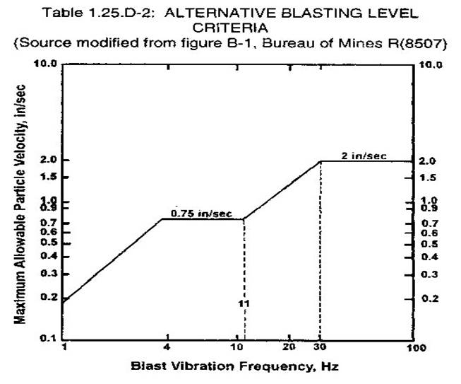
3. Blasting with
seismographic monitoring.
a. A permittee may use the
ground-vibration limits in Table 1.25.D-2 to determine the maximum allowable
peak particle velocity. If Table 1.25.D-2 is used, a seismographic record
including both particle velocity and vibration-frequency levels shall be
provided for each blast. The method for the analysis of the predominant
frequency contained in the blasting records shall be approved by the director
before implementation of this alternative blasting level.
b. The permittee may choose
to record every blast. As long as the seismographic records indicate particle
velocities have remained within the limits prescribed in Tables 1.25.D-1 or
1.25.D-2, the permittee shall be considered to be in compliance with this
subsection.
.§§
c. Ground vibration shall be
measured as the particle velocity. Particle velocity shall be recorded in three
mutually perpendicular directions. The maximum allowable peak particle velocity
shall apply to each of the three measurements.
d. All seismic tests carried
out for the purposes of this section shall be analyzed by a qualified
seismologist.
e. All seismic tests carried
out for the purposes of this section shall be conducted with a seismograph that
has an upper-end flat frequency response of at least 200 Hz.
E. Airblast shall not exceed
the maximum limits prescribed in Table 1.25.E-1 at the location of any
inhabited building. The 0.1 Hz or lower, flat response or C-weighted, slow
response shall be used only when approved by the director.
|
|
||
|
|
|
|
|
|
|
|
|
|
|
|
|
|
|
|
|
|
|
|
F. If the director concludes
that blasting on a particular site has potential to create unsafe conditions,
then he may:
1. Require the permittee to
monitor ground vibration and airblast for all blasts on the site for a
specified period of time;
2. Impose more stringent
limits on ground vibration and airblast levels than those specified in this
section. The director may order the permittee to obtain an evaluation of the
blast site by a vibration consultant or a technical representative of the
explosives manufacturer before imposing a more stringent limit. Blasting may
not resume on the site being evaluated until the evaluation and recommendations
are submitted to the director, and the director has given his approval.
G. Records.
1. The permittee shall keep
records of all blasts, and these records shall contain the following:
a. Name of company or
contractor;
b. Location, date, and time
of the blast;
c. Name, signature, and
certification number of the blaster in charge;
d. Type of material blasted;
e. Number of holes; their
burden and spacing;
f. Diameter and depth of the
holes;
g. Types of explosives used;
h. Total amount of
explosives used per hole;
i. Maximum weight of
explosives per delay period;
j. Method of firing and the
type of circuit;
k. Direction and distance in
feet to the nearest inhabited building;
l. Weather conditions
(including wind directions, etc.);
m. Height or length of
stemming;
n. Description of any mats
or other protection used;
o. Type of detonators and
delay periods used; and
p. Any seismograph reports,
including:
(1) The name and signature
of the person operating the seismograph;
(2) The name of the person
analyzing the seismograph record;
(3) The exact location of
the seismograph in relation to the blast;
(4) The date and time of the
reading; and
(5) The seismograph reading.
2. The permittee shall
retain all records of blasting, including seismograph reports, for at least
three years. On request, the permittee shall make these records available for
inspection by the director division.
4VAC25-150-260. Erosion,
sediment control and reclamation.
A. Applicability. Permittees
shall meet the erosion and sediment control standards of this section whenever
there is a ground disturbance for a gas, oil or geophysical operation.
Permittees shall reclaim the land to the standards of this section after the
ground-disturbing activities are complete and the land will not be used for
further permitted activities.
B. Erosion and sediment
control plan. Applicants for a permit shall submit an erosion and sediment
control plan as part of their operations plan. The plan shall describe how
erosion and sedimentation will be controlled and how reclamation will be
achieved.
C. Erosion and sediment
control standards. Whenever ground is disturbed for a gas, oil or geophysical
operation, the following erosion and sediment control standards shall be met.
1. All trees, shrubs and other vegetation
shall be cleared as necessary before any blasting, drilling, or other site
construction, including road construction, begins.
a. Cleared vegetation shall be either removed
from the site, properly stacked on the permitted site for later use, burned, or
placed in a brush barrier if needed to control erosion and sediment control.
Only that material necessary for the construction of the permitted site shall
be cleared. When used as a brush barrier, the cleared vegetation shall be cut
and windrowed below a disturbed area so that the brush barrier will effectively
control sediment migration from the disturbed area. The material shall be
placed in a compact and uniform manner within the brush barrier and not
perpendicular to the brush barrier. Brush barriers shall be constructed so that
any concentrated flow created by the barrier is released into adequately
protected outlets and adequate channels. Large diameter trunks, limbs, and
stumps that may render the brush barrier ineffective for sediment control shall
not be placed in the brush barrier.
b. During construction of the project,
topsoil, soil sufficient to provide a suitable growth medium for
permanent stabilization with vegetation shall be segregated and stockpiled.
Soil stockpiles shall be stabilized used to stabilize the site in
accordance with the standards of subdivisions C 2 and C 3 of this section to
prevent erosion and sedimentation.
2. Except as provided for in subdivisions C 5
and C 12 c of this section, permanent or temporary stabilization measures shall
be applied to denuded areas within 30 days of achievement of final grade on the
site unless the area will be redisturbed within 30 days.
a. If no activity occurs on a site for a
period of 30 consecutive days then stabilization measures shall be applied to
denuded areas within seven days of the last day of the 30-day period.
b. Temporary stabilization measures shall be
applied to denuded areas that may not be at final grade but will be left
inactive for one year or less.
c. Permanent stabilization measures shall be
applied to denuded areas that are to be left inactive for more than one year.
3. A permanent vegetative cover shall be
established on denuded areas to achieve permanent stabilization on areas not
otherwise permanently stabilized. Permanent vegetation shall not be considered
established until a ground cover is uniform, mature enough to survive and will
inhibit erosion.
4. Temporary sediment control structures such
as basins, traps, berms or sediment barriers shall be constructed prior to
beginning other ground-disturbing activity and shall be maintained until the
site is stabilized.
5. Stabilization measures shall be applied to
earthen structures such as sumps, diversions, dikes, berms and drainage windows
within 30 days of installation.
6. Sediment basins.
a. Surface runoff from disturbed areas that
is composed of flow from drainage areas greater than or equal to three acres
shall be controlled by a sediment basin. The sediment basin shall be designed
and constructed to accommodate the anticipated sediment loading from the
ground-disturbing activity. The spillway or outfall system design shall take
into account the total drainage area flowing through the disturbed area to be
served by the basin.
b. If surface runoff that is composed of flow
from other drainage areas is separately controlled by other erosion and
sediment control measures, then the other drainage area is not considered when
determining whether the three-acre limit has been reached and a sediment basin
is required.
7. Cut and fill slopes shall be designed and
constructed in a manner that will minimize erosion. No trees, shrubs, stumps or
other woody material shall be placed in fill.
8. Concentrated runoff shall not flow down
cut or fill slopes unless contained within an adequate temporary or permanent
channel, flume or slope drain structure.
9. Whenever water seeps from a slope face,
adequate drainage or other protection shall be provided.
10. All storm sewer inlets that are made operable
during construction shall be protected so that sediment-laden water cannot
enter the conveyance system without first being filtered or otherwise treated
to remove sediment.
11. Before newly constructed stormwater
conveyance channels or pipes are made operational, adequate outlet protection
and any required temporary or permanent channel lining shall be installed in
both the conveyance channel and receiving channel.
12. Live watercourses.
a. When any construction required for erosion
and sediment control, reclamation or stormwater management must be performed in
a live watercourse, precautions shall be taken to minimize encroachment,
control sediment transport and stabilize the work area. Nonerodible material
shall be used for the construction of causeways and cofferdams. Earthen fill
may be used for these structures if armored by nonerodible cover materials.
b. When the same location in a live
watercourse must be crossed by construction vehicles more than twice in any
six-month period, a temporary stream crossing constructed of nonerodible
material shall be provided.
c. The bed and banks of a watercourse shall
be stabilized immediately after work in the watercourse is completed.
13. If more than 500 linear feet of trench is
to be open at any one time on any continuous slope, ditchline barriers shall be
installed at intervals no more than the distance in the following table and
prior to entering watercourses or other bodies of water.
|
|
Distance Barrier Spacing |
|
|
|
Percent of Grade |
Spacing of Ditchline
Barriers in Feet |
|
|
3–5 |
135 |
|
|
6–10 |
80 |
|
|
11–15 |
60 |
|
|
16+ |
40 |
14. Where construction vehicle access routes
intersect a paved or public road, provisions, such as surfacing the road, shall
be made to minimize the transport of sediment by vehicular tracking onto the
paved surface. Where sediment is transported onto a paved or public road
surface, the road surface shall be cleaned by the end of the day.
15. The design and construction or
reconstruction of roads shall incorporate appropriate limits for grade, width,
surface materials, surface drainage control, culvert placement, culvert size,
and any other necessary design criteria required by the director to ensure
control of erosion, sedimentation and runoff, and safety appropriate for their
planned duration and use. This shall include, at a minimum, that roads are to
be located, designed, constructed, reconstructed, used, maintained and
reclaimed so as to:
a. Control or prevent erosion and siltation
by vegetating or otherwise stabilizing all exposed surfaces in accordance with
current, prudent engineering practices;
b. Control runoff to minimize downstream
sedimentation and flooding; and
c. Use nonacid or nontoxic substances in road
surfacing.
16. Unless approved by the director, all
temporary erosion and sediment control measures shall be removed within 30 days
after final site stabilization or after the temporary measures are no longer
needed. Trapped sediment and the disturbed soil areas resulting from the
disposition of temporary measures shall be permanently stabilized within the
permitted area to prevent further erosion and sedimentation.
D. Final reclamation
standards.
1. All equipment, structures or other
facilities not required for monitoring the site or permanently marking an
abandoned well or corehole shall be removed from the site, unless otherwise
approved by the director.
2. Each pipeline abandoned in place shall
be disconnected from all sources of natural gas or produced fluids and purged.
Each gathering line abandoned in place, unless otherwise agreed to be
removed under a right-of-way or lease agreement, shall be disconnected from all
sources and supplies of natural gas and petroleum, purged of liquid
hydrocarbons, depleted to atmospheric pressure, and cut off three feet below
ground surface, or at the depth of the gathering line, whichever is less, and
sealed at the ends. The operator shall provide to the division documentation of
the methods used, the date and time the pipeline was purged and abandoned, and
copies of any right of way or lease agreements that apply to the abandonment or
removal.
3. If final stabilization measures are being
applied to access roads or ground-disturbed pipeline rights-of-way, or if the
rights-of-way will not be redisturbed for a period of 30 days, water bars shall
be placed across them at 30-degree angles at the head of all pitched grades and
at intervals no more than the distance in the following table:
|
|
Percent of Grade |
Spacing of Water Bars in
Feet |
|
|
3–5 |
135 |
|
|
6–10 |
80 |
|
|
11–15 |
60 |
|
|
16+ |
40 |
4. The permittee shall notify the division
when the site has been graded and seeded for final reclamation in accordance
with subdivision C 3 of this section. Notice may be given orally or in writing.
The vegetative cover shall be successfully maintained for a period of two years
after notice has been given before the site is eligible for bond release.
5. If the land disturbed during gas, oil or
geophysical operations will not be reclaimed with permanent vegetative cover as
provided for in subsection C of this section, the permittee or applicant shall,
in the operations plan, request a variance to these reclamation standards
and propose alternate reclamation standards and an alternate schedule for bond
release.
E. The director may waive or
modify any of the requirements of this section that are deemed inappropriate or
too restrictive for site conditions. A permittee requesting a variance shall,
in writing, document the need for the variance and describe the alternate
measures or practices to be used. Specific variances allowed by the director
shall become part of the operations plan. The director shall consider variance
requests judiciously, keeping in mind both the need of the applicant to
maximize cost effectiveness and the need to protect off-site properties and resources
from damage.
4VAC25-150-280. Logs and
surveys.
A. Each permittee drilling a
well or corehole shall complete a driller's log, a gamma ray log or other log
showing the top and bottom points of geologic formations and any other log
required under this section. The driller's log shall state, at a minimum, the
character, depth and thickness of geological formations encountered, including
groundwater-bearing strata, coal seams, mineral beds and gas- or oil-bearing
formations.
B. When a permittee or the
director identifies that a well or corehole is to be drilled or deepened in an
area of the Commonwealth which is known to be underlain by coal seams, the
following shall be required:
1. The vertical location of coal seams in the
borehole well or corehole shall be determined and shown in the
driller's log and gamma ray or other log.
2. The horizontal location of the borehole
well or corehole in coal seams shall be determined through an
inclination survey from the surface to the lowest known coal seam. Each inclination
survey shall be conducted as follows:
a. The first survey point shall be taken at a
depth not greater than the most shallow coal seam; and
b. Thereafter shot points shall be taken at
each coal seam or at intervals of 200 feet, whichever is less, to the lowest
known coal seam.
3. Prior to drilling any borehole into
well or corehole within 500 feet of a coal seam in which active
mining is being conducted within 500 feet of where the borehole will penetrate
the seam where workers are assigned or travel, as well as any connected
sealed or gob areas, or where a mine plan is on file with the Division of Mines,
the permittee shall conduct an inclination survey to determine whether the
deviation of the bore hole well or corehole exceeds one degree
from true vertical. If the borehole well or corehole is found to
exceed one degree from vertical, then the permittee shall:
a. Immediately cease operations;
b. Immediately notify the coal owner and the
division;
c. Conduct a directional survey to drilled
depth to determine both horizontal and vertical location of the borehole
well or corehole; and
d. Unless granted a variance by the director,
correct the borehole well or corehole to within one degree of
true vertical.
4. Except as provided for in subdivision B 3
of this section, if the deviation of the borehole well or corehole
exceeds one degree from true vertical at any point between the surface and the
lowest known coal seam, then the permittee shall:
a. Correct the borehole well or
corehole to within one degree of true vertical; or
b. Conduct a directional survey to the lowest
known coal seam and notify the coal owner of the actual borehole well
or corehole location.
5. The director may grant a variance to the
requirements of subdivisions B 3 and B 4 of this section only after the
permittee and coal owners have jointly submitted a written request for a
variance stating that a directional survey or correction to the borehole
well or corehole is not needed to protect the safety of any person
engaged in active coal mining or to the environment.
6. If the director finds that the lack of
assurance of the horizontal location of the bore of a well or corehole
to a known coal seam poses a danger to persons engaged in active coal mining or
the lack of assurance poses a risk to the public safety or the environment, the
director may, until 30 days after a permittee has filed the completion report
required in 4VAC25-150-360, require that a directional survey be conducted by
the permittee.
7. The driller's log shall be updated on a
daily basis. The driller's log and results of any other required survey shall
be kept at the site until drilling and casing or plugging a dry hole or
corehole are completed.
4VAC25-150-300. Pits.
A. General requirements.
1. Pits are to be temporary in nature and are
to be reclaimed when the operations using the pit are complete. All pits
shall be reclaimed within 90 days unless a variance is requested and granted by
the field inspector.
2. Pits may not be used as erosion and
sediment control structures or stormwater management structures, and surface
drainage may not be directed into a pit.
3. Pits shall have a properly installed and
maintained liner or liners made of 10 mil or thicker high-density polyethylene
or its equivalent.
B. Technical requirements.
1. 4. Pits shall be
constructed of sufficient size and shape to contain all fluids and maintain a
two-foot freeboard.
2. Pits shall be lined in
accordance with the requirements for liners in subdivision A 3 of this section.
If solids are not to be disposed of in the pit, the permittee may request a
variance to the liner specifications.
C. B. Operational
requirements.
1. The integrity of lined pits must be
maintained until the pits are reclaimed or otherwise closed. Upon failure of the
lining or pit, the operation shall be shut down until the liner and pit are
repaired or rebuilt. The permittee shall notify the division, by the quickest
available means, of any pit leak.
2. Motor oil and, to the extent practicable,
crude oil shall be kept out of the pit. Oil shall be collected and disposed of
properly. Litter and other solid waste shall be collected and disposed of
properly and not thrown into the pit.
3. At the conclusion of drilling and
completion operations or after a dry hole, well or corehole has been plugged,
the pit shall be drained in a controlled manner and the fluids disposed of in
accordance with 4VAC25-150-420. If the pit is to be used for disposal of
solids, then the standards of 4VAC25-150-430 shall be met.
4VAC25-150-310. Tanks.
A. All tanks installed on or
after September 25, 1991, shall be designed and constructed to contain the
fluids to be stored in the tanks and prevent unauthorized discharge of fluids.
B. All tanks shall be
maintained in good condition and repaired as needed to ensure the structural
integrity of the tank.
C. Every permanent tank or
battery of tanks shall be surrounded by a have secondary
containment achieved by constructing a dike or firewall with a capacity
of 1½ 1-1/2 times the volume of the single tank, or largest
tank in a battery of tanks largest tank when plumbed at the top, or all
tanks when plumbed at the bottom, utilizing a double wall tank or another
method approved by the division.
D. Dikes and firewalls shall
be maintained in good condition, and the reservoir shall be kept free from
brush, water, oil or other fluids.
E. Permittees shall inspect
the structural integrity of tanks and tank installations, at a minimum,
annually. The report of the annual inspection shall be maintained by the
permittee for a minimum of three years and be submitted to the director upon
request.
F. Load lines shall be
properly constructed and operated on the permitted area.
4VAC25-150-340. Drilling
fluids.
A. Operations plan
requirements. Applicants for a permit shall provide, prior to commencing
drilling, documentation that the water meets the requirements of subsection B
of this section, and a general description of the additives and muds to be used
in all stages of drilling. Providing that the requirement in 4VAC25-150-340 C
is met, variations necessary because of field conditions may be made with prior
approval of the director and shall be documented in the driller's log.
B. Water quality in
drilling.
1. Before the water-protection string is set,
permittees shall use one of the following sources of water in drilling:
a. Water that is from a water well or spring
located on the drilling site; or
b. Conduct an analysis of groundwater within
500 feet of the drilling location, and use:
(1) Water which is of equal or better quality
than the groundwater; or
(2) Water which can be treated to be of equal
or better quality than the groundwater. A treatment plan must be included with
the application if water is to be treated.
If, after a diligent search, a groundwater
source (such as a well or spring) cannot be found within 500 feet of the
drilling location, the applicant may use water meeting the parameters listed in
the Department of Environmental Quality's "Water Quality Criteria for
Groundwater," 9VAC25-260-230 et seq. The analysis shall include, but is
not limited to, the following items:
(1) Chlorides;
(2) Total dissolved solids;
(3) Hardness;
(4) Iron;
(5) Manganese;
(6) PH;
(7) Sodium; and
(8) Sulfate.
Drilling water analysis
shall be taken within a one-year period preceding the drilling application.
2. After the water-protection string is set,
permittees may use waters that do not meet the standards of subdivision B 1 of
this section.
C. Drilling muds. No
permittee may use an oil-based drilling fluid or other fluid which has the
potential to cause acute or chronic adverse health effects on living organisms
unless a variance has been approved by the director. Permittees must explain
the need to use such materials and provide the material data safety sheets. In
reviewing the request for the variance, the director shall consider the
concentration of the material, the measures to be taken to control the risks,
and the need to use the material. Permittees shall also identify what actions
will be taken to ensure use of the additives will not cause a lessening of
groundwater quality.
4VAC25-150-360. Drilling,
completion and other reports.
A. Each permittee conducting
drilling shall file, electronically or on a form prescribed by the
director, a drilling report within 30 90 days after a well
reaches total depth.
B. Each permittee drilling a
well shall file, electronically or on a form prescribed by the director,
a completion report within 30 90 days after the well is
completed.
C. The permittee shall file
the driller's log, the results of any other log or survey required to be run in
accordance with this chapter or by the director, and the plat showing the
actual location of the well with the drilling report, unless they have been
filed earlier.
D. The permittee shall,
within two years 90 days of reaching total depth, file with the
division the results of any gamma ray, density, neutron and induction logs, or
their equivalent, that have been conducted on the wellbore in the normal course
of activities that have not previously been required to be filed.
4VAC25-150-380. Accidents
Incidents, spills and unpermitted discharges.
A. Accidents. Incidents.
A permittee shall, by the quickest available means, notify the director division
in the event of any unplanned off-site disturbance, fire, blowout, pit
failure, hydrogen sulfide release, unanticipated loss of drilling fluids, or
other accident incident resulting in serious personal injury
or an actual or potential imminent danger to a worker, the
environment, or public safety or welfare. The permittee shall
take immediate action to abate the actual or potential danger. The permittee
shall submit a written or electronic report within seven days of the
incident containing:
1. A description of the incident and its cause;
2. The date, time and duration of the
incident;
3. A description of the steps that have been
taken to date; and
4. A description of the steps planned to be
taken to prevent a recurrence of the incident. ; and
5. Other agencies notified.
B. On-site spills.
1. A permittee shall take all reasonable
steps to prevent, minimize, or correct any spill or discharge of fluids on a
permitted site which has a reasonable likelihood of adversely affecting human
health or the environment. All actions shall be consistent with the
requirements of an abatement plan, if any has been set, in a notice of
violation or closure, emergency or other order issued by the director.
2. A permittee shall orally report on-site
spills or unpermitted discharges of fluids which are not required to be
reported in subsection A of this section to the division within 24 hours. The
oral report shall provide all available details of the incident, including any
adverse effects on any person or the environment. A written report shall be submitted
within seven days of the spill or unpermitted discharge. The written report
shall contain:
a. A description of the incident and its
cause;
b. The period of release, including exact
dates and times;
c. A description of the steps to date; and
d. A description of the steps to be taken to
prevent a recurrence of the release.
C. Off-site spills.
Permittees shall submit a written report of any spill or unpermitted discharge
of fluids that originates off of a permitted site with the monthly report under
4VAC25-150-210. The written report shall contain:
1. A listing of all agencies contacted about
the spill or unpermitted discharge; and
2. All actions taken to contain, clean up or
mitigate the spill or unpermitted discharge.
4VAC25-150-390. Shut-in wells.
A. If a well is shut-in or
otherwise not produced for a period of 12 consecutive months, the permittee
shall measure the shut-in pressure on the production string or strings and
report such pressures to the division annually. If the well is producing on
the backside or otherwise through the casing, the permittee shall measure the
shut-in pressure on the annular space.
B. A report of the pressure
measurements on the nonproducing well shall be maintained and
reported to the director annually by the permittee for a minimum maximum
period of three two years and be submitted to the director
upon request.
C. Should the well remain in
a nonproducing status for a period of two years, the permittee shall submit
either a well plugging plan or a future well production plan to the director. A
nonproducing well shall not remain unplugged for more than a three-year period
unless approved by the director.
4VAC25-150-420. Disposal of
pit and produced fluids.
A. Applicability. All fluids
from a well, pipeline or corehole shall be handled in a properly constructed
pit, tank or other type of container approved by the director.
A permittee shall not
dispose of fluids from a well, pipeline or corehole until the director has
approved the permittee's plan for permanent disposal of the fluids. Temporary
storage of pit or produced fluids is allowed with the approval of the director.
Other fluids shall be disposed of in accordance with the operations plan
approved by the director.
B. Application and plan. The
permittee shall submit an application for either on-site or off-site permanent
disposal of fluids on a form prescribed by the director. Maps and a narrative
describing the method to be used for permanent disposal of fluids must
accompany the application if the permittee proposes to land apply any fluids on
the permitted site. The application, maps, and narrative shall become part of
the permittee's operations plan.
C. Removal of free fluids.
Fluids shall be removed from the pit to the extent practical so as to leave no
free fluids. In the event that there are no free fluids for removal, the
permittee shall report this on the form provided by the director.
D. On-site disposal. The
following standards for on-site land application of fluids shall be met:
1. Fluids to be land-applied shall meet the parameters listed in the Department of Environmental Quality's "Water Quality Criteria for Groundwater" (9VAC25-260-230 et seq.). following criteria:
Acidity: <alkalinity
Alkalinity: >acidity
Chlorides: <5,000 mg/l
Iron: <7 mg/l
Manganese: <4 mg/l
Oil and Grease: < 15 mg/l
pH: 6-9 Standard Units
Sodium Balance: SAR of 8-12
Sodium Balance: SAR of 8-12
2. Land application of fluids shall be confined to the permitted area.
3. Fluids shall be applied in a manner which will not cause erosion or runoff. The permittee shall take into account site conditions such as slope, soils and vegetation when determining the rate and volume of land application on each site. As part of the application narrative, the permittee shall show the calculations used to determine the maximum rate of application for each site.
4. Fluid application shall not be conducted when the ground is saturated, snow-covered or frozen.
5. The following buffer zones shall be maintained unless a variance has been granted by the director:
a. Fluid shall not be applied closer than 25
feet from highways or property lines not included in the acreage shown in the
permit.
b. Fluid shall not be applied closer than 50
feet from surface watercourses, wetlands, natural rock outcrops, or sinkholes.
c. Fluid shall not be applied closer than 100
feet from water supply wells or springs.
6. The permittee shall monitor vegetation for
two years after the last fluid has been applied to a site. If any adverse
effects are found, the permittee shall report the adverse effects in writing to
the division.
7. The director may require monitoring of
groundwater quality on sites used for land application of fluids to determine
if the groundwater has been degraded.
E. Off-site disposal of
fluids.
1. Each permittee using an off-site facility
for disposal of fluids shall submit:
a. A copy of a valid permit for the disposal
facility to be used; and
b. Documentation that the facility will
accept the fluids.
2. Each permittee using an off-site facility
for disposal of fluids shall use a waste-tracking system to document the
movement of fluids off of a permitted site to their final disposition. Records
compiled by this system shall be reported to the division annually and
available for inspection on request. Such records shall be retained until
such time the injection well is reclaimed and has passed bond release.
4VAC25-150-460. Identifying
plugged wells and coreholes; plugging affidavit.
A. Abandoned wells and
coreholes shall be permanently marked in a manner as follows:
1. The marker shall extend not less than 30
inches above the surface and enough below the surface to make the marker
permanent.
2. The marker shall indicate the permittee's
name, the well name, the permit number and date of plugging.
B. A permittee may apply for
a variance from the director to use alternate permanent markers. Such alternate
markers shall provide sufficient information for locating the abandoned well or
corehole. Provisions shall also be made to provide for the physical detection
of the abandoned well or corehole from the surface by magnetic or other means including
a certified map with the utilization of current GPS surveys.
C. When any well or corehole
has been plugged or replugged in accordance with 4VAC25-150-435, two persons,
experienced in plugging wells or coreholes, who participated in the plugging of
a well or corehole, shall complete the plugging affidavit designated by the
director, setting forth the time and manner in which the well or corehole was
plugged and filled, and the permanent marker was placed.
D. One copy of the plugging
affidavit shall be retained by the permittee, one shall be mailed to any coal
owner or operator on the tract where the well or corehole is located, and one
shall be filed with the division within 30 90 days after the day
the well was plugged.
Part II
Conventional Gas and Oil Wells and Class II Injection Wells
4VAC25-150-490.
Applicability, conventional gas and oil wells and Class II injection wells.
A. Part II of this chapter
sets forth requirements unique to conventional gas and oil wells and wells
classified as Class II injection wells by the United States, Environmental
Protection Agency under 40 CFR Part 146, Section 146.5.
B. Permittees must comply
with the standards of general applicability in Part I of this chapter and with
the standards for conventional gas and oil and Class II injection wells in this
part, except that whenever the Environmental Protection Agency imposes a
requirement under the Underground Injection Control (UIC) Program, 40 CFR Part
146, Sections 146.3, 146.4, 146.5, 146.6, 146.7, 146.8, 146.22 and 146.23 that
governs an activity also governed by this chapter, the Environmental Protection
Agency requirement shall control and become part of the permit issued under
this chapter.
C. An application for a
permit for a Class II injection well which has not been previously drilled
under a permit from the director shall be submitted as an application for a new
permit. An application for a permit for conversion of a permitted gas or oil
well to a Class II injection well shall be submitted as an application for a
permit modification.
D. The director shall not
issue a permit for a Class II injection well until after the Environmental
Protection Agency has issued its permit for the injection well.
4VAC25-150-500. Application
for a permit, conventional well or Class II injection well.
A. In addition to the
requirements of 4VAC25-150-80 or 4VAC25-150-110, every application for a permit
or permit modification for a conventional gas or oil well or a Class II
injection well shall contain:
1. The approximate depth to which the well is
proposed to be drilled or deepened, or the actual depth to which the well has
been drilled;
2. The approximate depth and thickness, if
applicable, of all known coal seams, known groundwater-bearing strata, and
other known gas or oil strata between the surface and the depth to which the
well is proposed to be drilled;
3. If casing or tubing is proposed to be or
has been set, a description of the entire casing program, including the size of
each string of pipe, the starting point and depth to which each string is to be
or has been set, and the extent to which each string is to be or has been
cemented; and
4. If the proposed work is for a Class II injection
well, a copy of either the permit issued by, or the permit application filed
with the Environmental Protection Agency under the Underground Injection
Control Program.
5. An explanation of the
procedures to be followed to protect the safety of persons working in and
around an underground coal mine for any conventional well or Class II injection
well to be drilled within 200 feet of areas where workers are assigned or
travel, as well as any connected sealed or gob areas, or where a one-year mine plan
is on file with the Division of Mines; which shall, at a minimum, require that
notice of such drilling be given by the permittee to the mine operator and the
Chief of the Division of Mines at least 10 working days prior to drilling.
B. In addition to the
requirements of 4VAC25-150-80 and 4VAC25-150-110, every application for a
permit or permit modification for a conventional gas or oil well or a Class II
injection well may contain, if the proposed work is to drill, redrill or deepen
a well, a plan showing the proposed manner of plugging the well immediately
after drilling if the proposed well work is unsuccessful.
4VAC25-150-510. Plats, conventional
wells or Class II injection wells.
A. In addition to the
requirements of 4VAC25-150-90, every plat for a conventional gas or oil well
shall show:
1. The boundaries of any drilling unit
established by the board around the subject well;
2. The boundaries and acreage of the tract on
which the well is located or is to be located;
3. The boundaries and acreage of all other
tracts within one-half of the distance specified in § 45.1-361.17 of the Code
of Virginia or within one-half of the distance to the nearest well completed in
the same pool, whichever is less, or within the boundaries of a drilling unit
established by the board around the subject well;
4. Surface owners on the tract to be drilled
and on all other tracts within the unit where the surface of the earth is to be
disturbed;
5. All gas, oil or royalty owners on any
tract located within one half of the distance specified in § 45.1-361.17 of the
Code of Virginia or within one-half of the distance to the nearest well
completed in the same pool, whichever is less, or within the boundaries of a
drilling unit established by the board around the subject well;
6. Coal owners and mineral owners on the
tract to be drilled and on all other tracts located within 500 feet of the
subject well location;
7. Coal operators who have registered
operations plans with the department for activities located on the tract to be
drilled, or who have applied for or obtained a coal mine license, coal surface
mine permit or a coal exploration notice or permit from the department with
respect to all tracts within 500 feet of a proposed gas or oil well;
8. Any inhabited building, highway, railroad,
stream, permitted surface mine or permitted mine opening within
500 feet of the proposed well; and
9. If the plat is for an enhanced oil
recovery injection well, any other well within 2,500 feet of the proposed or
actual well location, which shall be presumed to embrace the entire area to be
affected by an enhanced oil recovery injection well in the absence of a board
order establishing units in the target pool of a different size or
configuration.
B. If the well location is
underlain by known coal seams, or if required by the director, the well plat
shall locate the well and two permanent points or landmarks with reference to
the mine coordinate system if one has been established for the area of the well
location, and shall in any event show all other wells, surface mines and mine
openings within the scope of the plat.
4VAC25-150-520. Setback
restrictions, conventional wells or Class II injection wells.
No permit shall be issued
for any well to be drilled closer than 200 feet from any inhabited building
unless site conditions as approved by the director warrant the permission of a
lesser distance and there exists a lease or agreement between the operator and
the owner of the inhabited building. A copy of the lease or agreement shall accompany
the application for a permit.
4VAC25-150-530. Casing
requirements for conventional gas or oil wells.
A. Water-protection string.
1. Except as provided in subdivision A 5 of
this section, the permittee shall set a water-protection string to a point at
least 300 feet below the surface or 50 feet below the deepest known groundwater
horizon, whichever is deeper, circulated and cemented in to the surface. If the
cement does not return to the surface, every reasonable attempt shall be made
to fill the annular space by introducing cement from the surface.
2. The operator shall test or require the
cementing company to test the cement mixing water for pH and temperature prior
to mixing the cement and to record the results on the cementing ticket.
3. After the cement is placed, the operator
shall wait a minimum of eight hours and allow the cement to achieve a
calculated compressive strength of 500 psi before drilling, unless the director
approves a shorter period of time. The wait-on-cement (WOC) time shall be
recorded within the records kept at the drilling rig while drilling is taking
place.
4. When requested by the director, the
operator shall submit copies of cement tickets or other documents that indicate
the above specifications have been followed.
5. A coal-protection string may also serve as
a water-protection string.
B. Coal-protection strings.
1. When any well penetrates coal seams that
have not been mined out, the permittee shall, except as provided in
subdivisions B 2 and B 3 of this section, set a coal-protection string. The
coal-protection string shall exclude all fluids, oil, gas and gas pressure
except that which is naturally present in each coal seam. The coal-protection
string shall also exclude all injected material or disposed waste from the coal
seams and the wellbore. The string of casing shall be set to a point at least
50 feet below the lowest coal seam, or as provided in subdivision B 3 of this
section, and shall be circulated and cemented from that point to the surface or
to a point not less than 50 feet into the water-protection string or strings
which are cemented to the surface.
2. For good cause shown, either before or
after the permit is issued, when the procedure specified in subdivision B 1 is
demonstrated by the permittee as not practical, the director may approve a
casing program involving the cementing of a coal-protection string in multiple
stages, or the cementing of two or more coal-protection strings, or the use of
other alternative casing procedures. The director may approve the program
provided he is satisfied that the result will be operationally equivalent to
compliance with the provisions of subdivision B 1 of this section for the
purpose of permitting the subsequent safe mining through of the well or
otherwise protecting the coal seams as required by this section. In the use of
multiple coal-protection strings, each string below the topmost string shall be
cemented at least 50 feet into the next higher string or strings that are
cemented to the surface and be verified by a cement top log.
3. Depth of coal-protection strings:
a. A coal-protection string shall be set to
the top of the red shales in any area underlain by them unless, on a showing by
the permittee in the permit application, the director has approved the casing
point of the coal-protection string at some depth less than the top of the red
shales. In such event, the permittee shall conduct a gamma ray/density log
survey on an expanded scale to verify whether the well penetrates any coal seam
in the uncased interval between the bottom of the coal-protection string as
approved and the top of the red shales.
b. If an unanticipated coal seam or seams are
discovered in the uncased interval, the permittee shall report the discovery in
writing to the director. The permittee shall cement the next string of casing,
whether a part of the intermediate string or the production string, in the
applicable manner provided in this section for coal-protection strings, from a
point at least 50 feet below the lowest coal seam so discovered to a point at
least 50 feet above the highest coal seam so discovered.
c. The gamma ray/density log survey shall be
filed with the director at the same time the driller's log is filed under
4VAC25-150-360.
d. When the director believes, after
reviewing documentation submitted by the permittee, that the total drilling in
any particular area has verified the deepest coal seam higher than the red
shales, so that further gamma ray/density logs on an expanded scale are
superfluous for the area, he may waive the constructing of a coal-protection
string or the conducting of such surveys deeper than 100 feet below the
verified depth of the deepest coal seam.
C. Coal-protection strings
of wells drilled prior to July 1, 1982. In the case of wells drilled prior to
July 1, 1982, through coal seams without coal-protection strings substantially
as prescribed in subsection B of this section, the permittee shall retain such
coal-protection strings as were set. During the life of the well, the permittee
shall, consistent with a plan approved by the director, keep the annular spaces
between the various strings of casing adjacent to coal seams open to the extent
possible, and the top ends of all such strings shall be provided with casing
heads, or such other approved devices as will permit the free passage of gas or
oil and prevent filling of the annular spaces with dirt or debris.
D. Producing from more than
one stratum. The casing program for any well designed or completed to produce
from more than one stratum shall be designed in accordance with the appropriate
standard practices of the industry.
E. Casing through voids.
1. When a well is drilled through a void, the
hole shall be drilled at least 30 feet below the void, the annular space shall
be cemented from the base of the casing up to the void and to the surface
from the top of the void, and every reasonable attempt shall be made to
fill the annular space from the top of the void to the surface, or it shall
be cemented at least 50 feet into the next higher string or strings of casing
that are cemented to the surface and be verified by a cement top log.
2. For good cause shown, the director may
approve alternative casing procedures proposed by the permittee, provided that
the director is satisfied that the alternative casing procedures are
operationally equivalent to the requirements imposed by subdivision E 1 of this
section.
3. For good cause shown, the director may
impose special requirements on the permittee to prevent communication between
two or more voids.
F. A well penetrating a mine
other than a coal mine. In the event that a permittee has requested to drill a
well in such a location that it would penetrate any active mine other than a
coal mine, the director shall approve the safety precautions to be followed by
the permittee prior to the commencement of activity.
G. Reporting of lost
circulation zones. The permittee shall report to the director as soon as
possible when an unanticipated void or groundwater horizon is encountered that
results in lost circulation during drilling. The permittee shall take every
necessary action to protect the lost circulation zone.
Part III
Coalbed Methane Gas Wells
4VAC25-150-550.
Applicability, coalbed methane wells.
Part III of this chapter
sets forth requirements unique to coalbed methane gas wells. Permittees must
comply with the standards of general applicability in Part I of this chapter
and with the standards for coalbed methane gas wells in this part.
4VAC25-150-560. Application
for a permit, coalbed methane well operations.
A. In addition to the
requirements of 4VAC25-150-80 or 4VAC25-150-110, every application for a permit
or permit modification for a coalbed methane gas well shall contain:
1. An identification of the category of owner
or operator, as listed in § 45.1-361.30 A of the Code of Virginia, that each
person notified of the application belongs to;
2. The signed consent required in §
45.1-361.29 of the Code of Virginia;
3. Proof of conformance with any mine
development plan in the vicinity of the proposed coalbed methane gas well, when
the Virginia Gas and Oil Board has ordered such conformance;
4. The approximate depth to which the well is
proposed to be drilled or deepened, or the actual depth if the well has been
drilled;
5. The approximate depth and thickness, if
applicable, of all known coal seams, known groundwater-bearing strata, and
other known gas or oil strata between the surface and the depth to which the
well is proposed to be drilled;
6. If casing or tubing is proposed to be or
has been set, a description of the entire casing program, including the size of
each string of pipe, the starting point and depth to which each string is to be
or has been set, and the extent to which each string is to be or has been
cemented together with any request for a variance under 4VAC25-150-580;
7. An explanation of the procedures to be
followed to protect the safety of persons working in and around an
underground coal mine for any coalbed methane gas well to be drilled within 200
feet of or into any area of an active underground coal mine areas
where workers are assigned or travel, as well as any connected sealed or gob
areas, or where a one-year mine plan is on file with the Division of Mines;
which shall, at a minimum, require that notice of such drilling be given by the
permittee to the mine operator and the Chief of the Division of Mines at
least two 10 working days prior to drilling within 200 feet of
or into the mine; and
8. If the proposed work is for a Class II
injection well, a copy of the Environmental Protection Agency permit, or a copy
of the application filed with the Environmental Protection Agency under the
Underground Injection Control Program.
B. In addition to the
requirements of 4VAC25-150-80 or 4VAC25-150-110, every application for a permit
or permit modification for a coalbed methane well or a Class II injection well
may contain, if the proposed work is to drill, redrill or deepen a well, a plan
showing the proposed manner of plugging the well immediately after drilling if the
proposed well work is unsuccessful so that the well must be plugged and
abandoned.
4VAC25-150-590. Plats,
coalbed methane wells.
A. In addition to the
requirements of 4VAC25-150-90, every plat for a coalbed methane gas well shall
show:
1. Boundaries and acreage of any drilling
unit established by the board around the subject well;
2. Boundaries and acreage of the tract on
which the well is located or is to be located;
3. Boundaries and acreage of all other tracts
within one-half of the distance specified in § 45.1-361.17 of the Code of
Virginia or within one-half of the distance to the nearest well completed in
the same pool, whichever is less, or within the boundaries of a drilling unit
established by the board around the subject well;
4. Surface owners on the tract to be drilled
and on all other tracts within the unit where the surface of the earth is to be
disturbed;
5. All gas, oil or royalty owners on any
tract located within one-half of the distance specified in § 45.1-361.17 of the
Code of Virginia or within one-half of the distance to the nearest well
completed in the same pool, whichever is less, or within the boundaries of a
drilling unit established by the board around the subject well;
6. Coal owners and mineral owners on the
tract to be drilled and on all other tracts located within 750 feet of the
subject well location;
7. Coal operators who have registered
operations plans with the department for activities located on the tract to be
drilled, or who have applied for or obtained a coal mine license, coal surface
mine permit or a coal exploration notice or permit from the department with
respect to all tracts within 750 feet of a proposed gas or oil well; and
8. Any inhabited building, highway, railroad,
stream, permitted surface mine or permitted mine opening within
500 feet of the proposed well.
B. The well plat shall
locate the well and two permanent points or landmarks with reference to the
mine coordinate system if one has been established for the area of the well
location, and shall show all other wells within the scope of the plat.
4VAC25-150-600. Setback
restrictions, coalbed methane wells.
No permit shall be issued
for any well to be drilled closer than 200 feet from any inhabited building,
unless site conditions as approved by the director warrant the permission of a
lesser distance, and there exists a lease or agreement between the operator and
the owner of the inhabited building. A copy of the lease or agreement shall
accompany the application for a permit.
4VAC25-150-610. Casing
requirements for coalbed methane gas wells.
A. Water protection string.
1. Except as provided in subdivision A 5 of
this section, the permittee shall set a water-protection string set to a point
at least 300 feet below the surface or 50 feet below the lowest deepest
known groundwater horizon, whichever is deeper, circulated and cemented to
the surface. If cement does not return to the surface, every reasonable effort
shall be made to fill the annular space by introducing cement from the surface.
2. The operator shall test or require the
cementing company to test the cement mixing water for pH and temperature prior
to mixing the cement and to record the results on the cementing ticket.
3. After the cement is placed, the operator
shall wait a minimum of eight hours and allow the cement to achieve a
calculated compressive strength of 500 psi before drilling, unless the director
approves a shorter period of time. The wait-on-cement (WOC) time shall be
recorded within the records kept at the drilling rig while drilling is taking
place.
4. When requested by the director, the
operator shall submit copies of cement tickets or other documents that indicate
the above specifications have been followed.
5. A coal-protection string may also serve as
a water protection string.
B. Coal protection strings.
1. When any well penetrates coal seams that
have not been mined out, the permittee shall, except as provided in
subdivisions B 2 and B 3 of this section, set a coal-protection string. The
coal-protection string shall exclude all fluids, oil, gas, and gas pressure,
except that which is naturally present in each coal seam. The coal-protection
string shall also exclude all injected material or disposed waste from the coal
seams or the wellbore. The string of casing shall be set to a point at least 50
feet below the lowest coal seam, or as provided in subdivision B 3 of this
section, and shall be circulated and cemented from that point to the surface,
or to a point not less than 50 feet into the water-protection string or strings
which are cemented to the surface.
2. For good cause shown, either before or
after the permit is issued, when the procedure specified in subdivision B 1 is
demonstrated by the permittee as not practical, the director may approve a
casing program involving:
a. The cementing of a coal-protection string
in multiple stages;
b. The cementing of two or more
coal-protection strings; or
c. The use of other alternative casing
procedures.
3. The director may approve the program,
provided he is satisfied that the result will be operationally equivalent to
compliance with the provisions of subdivision B 1 of this section for the
purpose of permitting the subsequent safe mining through the well or otherwise
protecting the coal seams as required by this section. In the use of multiple
coal-protection strings, each string below the topmost string shall be cemented
at least 50 feet into the next higher string or strings that are cemented to
the surface and be verified by a cement top log.
4. Depth of coal-protection strings.
a. A coal-protection string shall be set to
the top of the red shales in any area underlain by them unless, on a showing by
the permittee in the permit application, the director has approved the casing
point of the coal-protection string at some depth less than the top of the red
shales. In such event, the permittee shall conduct a gamma-ray/density log
survey on an expanded scale to verify whether the well penetrates any coal seam
in the uncased interval between the bottom of the coal-protection string
as approved and the top of the red shales.
b. If an unanticipated coal seam or seams are
discovered in the uncased interval, the permittee shall report the discovery in
writing to the director. The permittee shall cement the next string of casing,
whether a part of the intermediate string or the production string, in the
applicable manner provided in this section for coal-protection strings, from a
point at least 50 feet below the lowest coal seam so discovered to a point at
least 50 feet above the highest coal seam so discovered.
c. The gamma-ray/density log survey shall be
filed with the director at the same time the driller's log is filed under
4VAC25-150-360.
d. When the director believes, after
reviewing documentation submitted by the permittee, that the total drilling in
any particular area has verified the deepest coal seam higher than the red
shales, so that further gamma-ray/density logs on an expanded scale are
superfluous for the area, he may waive the constructing of a coal-protection
string or the conducting of such surveys deeper than 100 feet below the
verified depth of the deepest coal seam.
C. Coal-protection strings
of wells drilled prior to July 1, 1982. In the case of wells drilled prior to
July 1, 1982, through coal seams without coal-protection strings as prescribed
in subsection B of this section, the permittee shall retain such
coal-protection strings as were set. During the life of the well, the permittee
shall, consistent with a plan approved by the director, keep the annular spaces
between the various strings of casing adjacent to coal seams open to the extent
possible, and the top ends of all such strings shall be provided with casing
heads, or such other approved devices as will permit the free passage of gas or
oil and prevent filling of the annular spaces with dirt or debris.
D. Producing from more than
one stratum. The casing program for any well designed or completed to produce
from more than one stratum shall be designed in accordance with the appropriate
standard practices of the industry.
E. Casing through voids.
1. When a well is drilled through a void, the
hole shall be drilled at least 30 feet below the void. The annular space shall
be cemented from the base of the casing up to the void, and to the surface
from the top of the void every reasonable attempt shall be made to fill
up the annular space from the top of the void to the surface; or it shall
be cemented at least 50 feet into the next higher string or strings of casing
that are cemented to the surface, and shall be verified by a cement top log.
2. For good cause shown, the director may
approve alternate casing procedures proposed by the permittee, provided that
the director is satisfied that the alternative casing procedures are
operationally equivalent to the requirements imposed by subdivision E 1 of this
section.
3. For good cause shown, the director may
impose special requirements on the permittee to prevent communication between
two or more voids.
F. A well penetrating a mine
other than a coal mine. In the event that a permittee has requested to drill a
well in such a location that it would penetrate any active mine other than a
coal mine, the director shall approve the safety precautions to be followed by
the permittee prior to the commencement of activity.
G. Production casing.
1. Unless otherwise granted in a variance
from the director:
a. For coalbed methane gas wells with cased
completions and cased/open hole completions, production casing shall be set and
cemented from the bottom of the casing to the surface or to a point not less
than 50 feet into the lowest coal-protection or water-protection string or
strings which are cemented to the surface.
b. For coalbed methane gas wells with open
hole completions, the base of the casing shall be set to not more than 100 feet
above the uppermost coalbed which is to be completed open hole. The casing
shall be cemented from the bottom of the casing to the surface or to a point
not less than 50 feet into the lowest coal-protection or water-protection
string or strings which are cemented to the surface.
2. A coal-protection string may also serve as
production casing.
H. Reporting of lost
circulation zones. The permittee shall report to the director as soon as
possible when an unanticipated void or groundwater horizon is encountered that
results in lost circulation during drilling. The permittee shall take every
necessary action to protect the lost circulation zone.
4VAC25-150-620. Coalbed
methane gas wellhead equipment.
Wellhead equipment and facilities
installed on any gob well or on any coalbed methane gas well subject to the
requirements of §§ 45.1-161.121 and 45.1-161.292 of the Code of Virginia
addressing mining near or through a well shall include a safety precaution
plan submitted to the director for approval. Such plans shall include, but are
shall not be limited to, flame arrestors, back-pressure systems,
pressure-relief systems, vent systems and fire-fighting equipment. The director
may require additional safety precautions or equipment to be installed
on a case-by-case basis.
4VAC25-150-630. Report of
produced waters, coalbed methane wells.
All coalbed methane gas well
operators are required to submit monthly reports of total produced waters
withdrawn from coalbed methane gas wells, in barrels, on a well-by-well basis,
with the monthly report submitted under 4VAC25-150-210 of this chapter. The
report shall show monthly produced water withdrawals and cumulative produced
water withdrawals. Such reports shall be available for inspection upon
request and maintained electronically or by hard copy until the well is
abandoned and reclaimed.
4VAC25-150-650. Abandonment
through conversion Conversion of a coalbed methane well to a
vertical ventilation hole.
A permittee wishing to abandon
convert a coalbed methane gas well as to a vertical
ventilation hole shall first obtain approval from the Chief of the Division
of Mines and submit an application a written request to the
division for a permit modification which includes approval from the
chief of the Division of Mines release. The director shall
consult with the chief, or his designated agent, before approving permit
release.
Part IV
Ground-Disturbing Geophysical Exploration
4VAC25-150-660.
Applicability, ground-disturbing geophysical activity.
Part IV (4VAC25-150-660 et
seq.) of this chapter sets forth requirements unique to ground-disturbing
geophysical exploration.
4VAC25-150-670. Application
for a permit, geophysical activity or core holes.
A. In accordance with
4VAC25-150-80 and 4VAC25-150-110, a permit shall be required for
ground-disturbing geophysical exploration.
B. In addition to the
requirements of 4VAC25-150-80 or 4VAC25-150-110, every application for a
corehole permit or permit modification under this part shall contain:
1. The approximate depth to which the
corehole is proposed to be drilled or deepened, or the actual depth if the
corehole has been drilled;
2. The approximate depth and thickness, if
applicable, of all known coal seams, known groundwater-bearing strata, and
other known gas or oil strata between the surface and the depth to which the
corehole is proposed to be drilled;
3. If casing is proposed to be set, the
entire casing program, including the diameter of each string of casing, the
starting point and depth to which each string is to be set, whether or not the
casing is to remain in the hole after the completion of drilling, and the
extent to which each string is to be cemented, if applicable; and
4. A plan which shows the proposed manner of
plugging or replugging the corehole.; and
5. An explanation of the
procedures to be followed to protect the safety of persons working in and
around an underground coal mine for any corehole to be drilled within 200 feet
of areas where workers are assigned or travel, as well as any connected sealed
or gob areas, or where a one-year mine plan is on file with the Division of
Mines. Such procedures shall, at a minimum, require that notice of such
drilling be given by the permittee to the mine operator and the Chief of the
Division of Mines at least 10 working days prior to drilling.
4VAC25-150-680. Plats,
core holes.
A. In addition to the
requirements of 4VAC25-150-90, every plat for a corehole shall show:
1. The boundaries of the tract on which the
corehole is located or is to be located;
2. Surface owners on the tract to be drilled
and surface owners on the tracts where the surface is to be disturbed;
3. Coal owners and mineral owners on the
tract to be drilled;
4. Coal operators who have registered
operations plans with the department for activities located on the tract to be
drilled; and
5. Any inhabited building, highway, railroad,
stream, permitted surface mine or permitted mine opening within
500 feet of the proposed corehole.
B. If the corehole location
is underlain by known coal seams, the plat shall locate the corehole and two
permanent points or landmarks with reference to the mine coordinate system if
one has been established for the area of the corehole location, and shall in
any event show all other wells within the scope of the plat.
4VAC25-150-690. Operations
plans, core holes.
In addition to the
requirements of 4VAC25-150-100, every operations plan for a corehole shall
describe the measures to be followed to protect water quality during the
drilling, and the measures to be followed to protect any voids encountered
during drilling.
4VAC25-150-700. Setback
restrictions, core holes.
No permit shall be issued
for any corehole to be drilled closer than 200 feet from an inhabited building,
unless site conditions as approved by the director warrant the permission of a
lesser distance, and there exists a lease or agreement between the operator and
the owner of the inhabited building. A copy of the lease or agreement shall
accompany the application for a permit.
4VAC25-150-711. Voids and
lost circular circulation zones.
A. Casing through voids.
1. When a corehole is drilled through a void,
the hole shall be drilled at least 30 feet below the void. The annular space
shall be cemented from the base of the casing up to the void and to the
surface from the top of the void every reasonable attempt shall be made
to fill the annular space from the top of the void to the surface; or it
shall be cemented at least 50 feet into the next higher string or strings of
casing that are cemented to the surface and be verified by a cement top log.
2. For good cause shown, the director may
approve alternate casing procedures proposed by the permittee, provided that
the director is satisfied that the alternative casing procedures are operationally
equivalent to the requirements imposed by this section.
3. For good cause shown, the director may
impose special requirements on the permittee to prevent communication between
two or more voids.
B. Reporting of lost
circulation zones. The permittee shall report to the director as soon as
possible when an unanticipated void or groundwater horizon is encountered that
results in lost circulation during drilling. The permittee shall take every
necessary action to protect the lost circulation zone.
Part V
Gathering Pipelines
4VAC25-150-720.
Applicability, gathering pipelines.
A. Part V (4VAC25-150-720 et
seq.) of this chapter sets forth requirements unique to gathering pipelines.
Permittees must comply with the standards for gathering pipelines in this part
and the following standards in Part I:
1. All of Article 1, "General
Information"; except 4VAC25-150-50, "Gas or oil in holes not
permitted as a gas or oil well";
2. All of Article 2, "Permitting";
except 4VAC25-150-90, "Plats";
3. All of the sections in Article 3,
"Enforcement";
4. 4VAC25-150-220, "Annual
reports,"; of Article 4, "Reporting";
5. 4VAC25-150-230, 4VAC25-150-240,
4VAC25-150-250, 4VAC25-150-260, 4VAC25-150-270, 4VAC25-150-310, 4VAC25-150-350,
4VAC25-150-380, 4VAC25-150-410, 4VAC25-150-420, and 4VAC25-150-430 of Article
5, "Technical Standards"; and
6. 4VAC25-150-470, "Release of
bond,"; of Article 6, "Plugging and Abandonment.";.
B. A permit shall be
required for installation and operation of every gathering pipeline and associated
structures for the movement of gas or oil production from the wellhead to a
previously permitted gathering line, a transmission or other line regulated by
the United States Department of Transportation or the State Corporation
Commission, to the first point of sale, or for oil, to a temporary storage
facility for future transportation by a method other than a gathering pipeline.
C. Each gathering pipeline
or gathering pipeline system may be permitted separately from gas or oil wells
or may be included in the permit for the well being served by the pipeline.
4VAC25-150-730. General
requirements for gathering pipelines.
A. Gathering pipelines shall
be installed to be compatible with other uses of the area.
B. No permit shall be issued
for a gathering pipeline to be installed closer than 50 100 feet
from any inhabited building or railway, unless site conditions as
approved by the director warrant the use of a lesser distance and there exists
a lease or agreement between the operator, the inhabitants of the building
and the owner of the inhabited building or railway. A copy of the lease
or agreement shall accompany the application for a permit.
C. Materials used in
gathering pipelines shall be able to withstand anticipated conditions. At a
minimum this shall include:
1. All plastic gathering pipeline connections
shall be fused, not coupled.
2. All buried gathering pipelines shall be
detectable by magnetic or other remote means from the surface.
D. All new gathering
pipelines shall be tested to maintain a minimum of 110% of anticipated pressure
prior to being placed into service.
E. All gathering pipelines
shall be maintained in good operating condition at all times.
4VAC25-150-740. Operations
plans for gathering pipelines.
A. For a gathering pipeline,
the operations plan shall be in a format approved by, or on a form prescribed
by, the director.
B. On a form prescribed by
the director, the operator shall indicate how risks to the public safety or to
the site and adjacent lands are to be managed, and shall provide a short
narrative, if pertinent.
4VAC25-150-750. Inspections for
gathering pipelines.
Gathering pipelines shall be
visually inspected annually by the permittee. The results of each annual
inspection shall be maintained by the permittee for a minimum of three years
and be submitted to the director upon request.
VA.R. Doc. No. R08-1318;
Filed August 12, 2009, 11:15 a.m.